
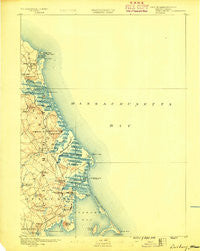
~ Duxbury MA topo map, 1:62500 scale, 15 X 15 Minute, Historical, 1888
Duxbury, Massachusetts, USGS topographic map dated 1888.
Includes geographic coordinates (latitude and longitude). This topographic map is suitable for hiking, camping, and exploring, or framing it as a wall map.
Printed on-demand using high resolution imagery, on heavy weight and acid free paper, or alternatively on a variety of synthetic materials.
Topos available on paper, Waterproof, Poly, or Tyvek. Usually shipping rolled, unless combined with other folded maps in one order.
- Product Number: USGS-5635345
- Free digital map download (high-resolution, GeoPDF): Duxbury, Massachusetts (file size: 6 MB)
- Map Size: please refer to the dimensions of the GeoPDF map above
- Weight (paper map): ca. 55 grams
- Map Type: POD USGS Topographic Map
- Map Series: HTMC
- Map Verison: Historical
- Cell ID: 53630
- Scan ID: 352590
- Survey Year: 1885
- Datum: Unstated
- Map Projection: Unstated
- Map published by United States Geological Survey
- Map Language: English
- Scanner Resolution: 600 dpi
- Map Cell Name: Duxbury
- Grid size: 15 X 15 Minute
- Date on map: 1888
- Map Scale: 1:62500
- Geographical region: Massachusetts, United States
Neighboring Maps:
All neighboring USGS topo maps are available for sale online at a variety of scales.
Spatial coverage:
Topo map Duxbury, Massachusetts, covers the geographical area associated the following places:
- Kent Park - Scituate Station - Sand Hills - Greenbush - Marshfield Center - Tarkiln - Northwest Duxbury - Baileys Corner - Rivermoor - First Cliff - Miramar - Rexhame - South Duxbury - Cedar Crest - Miles Standish Park - Ferry Hill - Marshfield Hills - Old Mouth North River - Mann Hill Beach - Green Harbor - Humarock - Little Bridge - Second Cliff - Brant Rock - Marshfield - Duxbury - Egypt Beach - Camp Chappa Challa - Fieldston - Island Creek - Cox Corner - Hatherly Beach - Shore Acres - Sea View - Ocean Bluff - Tree of Knowledge Corner - Third Cliff - Scituate - Tinkertown - North Duxbury - Fourth Cliff - Millbrook
- Map Area ID: AREA42.2542-70.75-70.5
- Northwest corner Lat/Long code: USGSNW42.25-70.75
- Northeast corner Lat/Long code: USGSNE42.25-70.5
- Southwest corner Lat/Long code: USGSSW42-70.75
- Southeast corner Lat/Long code: USGSSE42-70.5
- Northern map edge Latitude: 42.25
- Southern map edge Latitude: 42
- Western map edge Longitude: -70.75
- Eastern map edge Longitude: -70.5


