
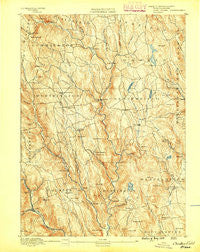
~ Chesterfield MA topo map, 1:62500 scale, 15 X 15 Minute, Historical, 1888
Chesterfield, Massachusetts, USGS topographic map dated 1888.
Includes geographic coordinates (latitude and longitude). This topographic map is suitable for hiking, camping, and exploring, or framing it as a wall map.
Printed on-demand using high resolution imagery, on heavy weight and acid free paper, or alternatively on a variety of synthetic materials.
Topos available on paper, Waterproof, Poly, or Tyvek. Usually shipping rolled, unless combined with other folded maps in one order.
- Product Number: USGS-5635307
- Free digital map download (high-resolution, GeoPDF): Chesterfield, Massachusetts (file size: 11 MB)
- Map Size: please refer to the dimensions of the GeoPDF map above
- Weight (paper map): ca. 55 grams
- Map Type: POD USGS Topographic Map
- Map Series: HTMC
- Map Verison: Historical
- Cell ID: 52479
- Scan ID: 352563
- Datum: Unstated
- Map Projection: Unstated
- Map published by United States Geological Survey
- Map Language: English
- Scanner Resolution: 600 dpi
- Map Cell Name: Chesterfield
- Grid size: 15 X 15 Minute
- Date on map: 1888
- Map Scale: 1:62500
- Geographical region: Massachusetts, United States
Neighboring Maps:
All neighboring USGS topo maps are available for sale online at a variety of scales.
Spatial coverage:
Topo map Chesterfield, Massachusetts, covers the geographical area associated the following places:
- Worthington Center - Lithia - Goshen - Knightville - Chester - Dayville - Littleville - Swift River - Chester Center - West Cummington - Bryant Four Corners - Worthington Corners - Ringville - Chesterfield - Westhampton - Goss Heights - Camp Howe - North Chester - East Windsor - Cummington - South Worthington - Norwich - West Chesterfield - West Worthington - Bisbee Mill
- Map Area ID: AREA42.542.25-73-72.75
- Northwest corner Lat/Long code: USGSNW42.5-73
- Northeast corner Lat/Long code: USGSNE42.5-72.75
- Southwest corner Lat/Long code: USGSSW42.25-73
- Southeast corner Lat/Long code: USGSSE42.25-72.75
- Northern map edge Latitude: 42.5
- Southern map edge Latitude: 42.25
- Western map edge Longitude: -73
- Eastern map edge Longitude: -72.75


