
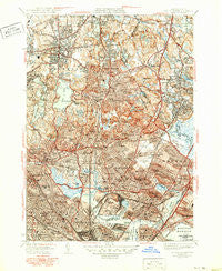
~ Boston North MA topo map, 1:31680 scale, 7.5 X 7.5 Minute, Historical, 1946, updated 1950
Boston North, Massachusetts, USGS topographic map dated 1946.
Includes geographic coordinates (latitude and longitude). This topographic map is suitable for hiking, camping, and exploring, or framing it as a wall map.
Printed on-demand using high resolution imagery, on heavy weight and acid free paper, or alternatively on a variety of synthetic materials.
Topos available on paper, Waterproof, Poly, or Tyvek. Usually shipping rolled, unless combined with other folded maps in one order.
- Product Number: USGS-5634073
- Free digital map download (high-resolution, GeoPDF): Boston North, Massachusetts (file size: 14 MB)
- Map Size: please refer to the dimensions of the GeoPDF map above
- Weight (paper map): ca. 55 grams
- Map Type: POD USGS Topographic Map
- Map Series: HTMC
- Map Verison: Historical
- Cell ID: 4930
- Scan ID: 351570
- Imprint Year: 1950
- Visual Version Number: 1
- Edit Year: 1949
- Survey Year: 1943
- Datum: NAD27
- Map Projection: Polyconic
- Map published by United States Geological Survey
- Map Language: English
- Scanner Resolution: 600 dpi
- Map Cell Name: Boston North
- Grid size: 7.5 X 7.5 Minute
- Date on map: 1946
- Map Scale: 1:31680
- Geographical region: Massachusetts, United States
Neighboring Maps:
All neighboring USGS topo maps are available for sale online at a variety of scales.
Spatial coverage:
Topo map Boston North, Massachusetts, covers the geographical area associated the following places:
- Faulkner - Maplewood - Haywardville - Merrimac Terrace - Wellington - Malden Centre - Greenwood - Chelsea - Winter Hill - Malden Highlands - Medford - East Somerville - Oakland Vale - Spring Hill - Malden - West Everett - Franklin Park - Wakefield Junction - Old Cambridge - Cliftondale - Montvale - West Somerville - Wyoming - Charlestown - East Boston - Stoneham - Orient Heights - Ten Hills - Everett - Cambridge - Somerville - Glendale - Hendersonville - Edgeworth - Avon Hill - Farm Hill - Revere - North Saugus - Lynnhurst - Pleasant Hills - Linden - Lindenwood - Oak Grove - Melrose Highlands - Melrose - Fells - Admirals Hill - Saugus - Glenwood
- Map Area ID: AREA42.542.375-71.125-71
- Northwest corner Lat/Long code: USGSNW42.5-71.125
- Northeast corner Lat/Long code: USGSNE42.5-71
- Southwest corner Lat/Long code: USGSSW42.375-71.125
- Southeast corner Lat/Long code: USGSSE42.375-71
- Northern map edge Latitude: 42.5
- Southern map edge Latitude: 42.375
- Western map edge Longitude: -71.125
- Eastern map edge Longitude: -71


