
~ Hartford CT topo map, 1:250000 scale, 1 X 2 Degree, Historical, 1948, updated 1948
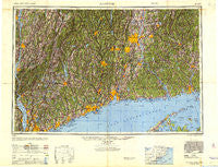
Hartford, Connecticut, USGS topographic map dated 1948.
Includes geographic coordinates (latitude and longitude). This topographic map is suitable for hiking, camping, and exploring, or framing it as a wall map.
Printed on-demand using high resolution imagery, on heavy weight and acid free paper, or alternatively on a variety of synthetic materials.
Topos available on paper, Waterproof, Poly, or Tyvek. Usually shipping rolled, unless combined with other folded maps in one order.
- Product Number: USGS-5631147
- Free digital map download (high-resolution, GeoPDF): Hartford, Connecticut (file size: 18 MB)
- Map Size: please refer to the dimensions of the GeoPDF map above
- Weight (paper map): ca. 55 grams
- Map Type: POD USGS Topographic Map
- Map Series: HTMC
- Map Verison: Historical
- Cell ID: 72228
- Scan ID: 707391
- Imprint Year: 1948
- Woodland Tint: Yes
- Aerial Photo Year: 1946
- Datum: NAD27
- Map Projection: Transverse Mercator
- Shaded Relief map: Yes
- Map published by United States Army Corps of Engineers
- Map published by United States Army
- Map published by United States Department of War
- Map Language: English
- Scanner Resolution: 508 dpi
- Map Cell Name: Hartford
- Grid size: 1 X 2 Degree
- Date on map: 1948
- Map Scale: 1:250000
- Geographical region: Connecticut, United States
Neighboring Maps:
All neighboring USGS topo maps are available for sale online at a variety of scales.
Spatial coverage:
Topo map Hartford, Connecticut, covers the geographical area associated the following places:
- Berkshire Estates - Millington - Leesville - Addison - Highland Park - Ridgebury - Scotts Corners - Miramichi - West Norwood - Wallingford - Beixedon Estates - Long HIll Estates - Newfield Heights - Ossining - Tiffany Hill Corner - Van Cortlandtville - Horton Estates - Milltown - Simsbury - Waterbury - West Morris - Ludingtonville - East Plymouth - Bigelow Corners - Strathmore Woods - Gilbert Corners - Emmons City (historical) - Spoonville - Higganum - Atwoodville - Cooper Road Mobile Home Park - Hattertown - North White Plains - North Salem - Port Chester - Sleightsburg - Johnson Park - Nelson Corners - Elmsford - Fair Lawn - Cornwall Bridge - Glendale - Wataba Lake - Lake Katonah - Laughing Waters - Warehouse Point - Paynes Corners - Cherry Park - Sarosca Farm Estates - Bay Point - Green Farms - Hyde Park Mobile Manor - Poughkeepsie - Kingston - Turkey Hill - Four Corners - Jefferson Village - Maromas - Newent - Hawleyville - North Cromwell - Peach Lake - Kent Furnace - Wildmans Landing - Cromwell - Samsondale - Skinnerville - McLaughlin Acres - Hibernia - Furnace Woods - Poquonock - Jordan - Couch Corners - Compo - Collinsville - Merrow - Reynolds Bridge - South Millbrook - South Lyme - Montville Center - Flanders (historical) - South End - Groton Long Point - Hoadley Neck - Fernbrook Park - Rock Landing - New Britain - Greens Farms - Rye Brook - Truesdale Lake - Bishops Corner - Willow Brook - Chaplin - Killingworth - Torringford - Canton Center - North Woodbury - Shelter Island - Oceola Lake - Waterville
- Map Area ID: AREA4241-74-72
- Northwest corner Lat/Long code: USGSNW42-74
- Northeast corner Lat/Long code: USGSNE42-72
- Southwest corner Lat/Long code: USGSSW41-74
- Southeast corner Lat/Long code: USGSSE41-72
- Northern map edge Latitude: 42
- Southern map edge Latitude: 41
- Western map edge Longitude: -74
- Eastern map edge Longitude: -72


