
~ Santa Maria CA topo map, 1:250000 scale, 2 X 1 Degree, Historical, 1948, updated 1948
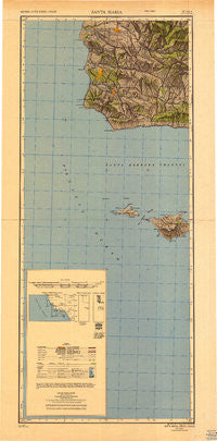
Santa Maria, California, USGS topographic map dated 1948.
Includes geographic coordinates (latitude and longitude). This topographic map is suitable for hiking, camping, and exploring, or framing it as a wall map.
Printed on-demand using high resolution imagery, on heavy weight and acid free paper, or alternatively on a variety of synthetic materials.
Topos available on paper, Waterproof, Poly, or Tyvek. Usually shipping rolled, unless combined with other folded maps in one order.
- Product Number: USGS-5631095
- Free digital map download (high-resolution, GeoPDF): Santa Maria, California (file size: 14 MB)
- Map Size: please refer to the dimensions of the GeoPDF map above
- Weight (paper map): ca. 55 grams
- Map Type: POD USGS Topographic Map
- Map Series: HTMC
- Map Verison: Historical
- Cell ID: 320753
- Scan ID: 707594
- Imprint Year: 1948
- Woodland Tint: Yes
- Aerial Photo Year: 1943
- Datum: NAD27
- Map Projection: Transverse Mercator
- Shaded Relief map: Yes
- Map published by United States Army Corps of Engineers
- Map published by United States Army
- Map Language: English
- Scanner Resolution: 508 dpi
- Map Cell Name: Santa Maria
- Grid size: 2 X 1 Degree
- Date on map: 1948
- Map Scale: 1:250000
- Geographical region: California, United States
Neighboring Maps:
All neighboring USGS topo maps are available for sale online at a variety of scales.
Spatial coverage:
Topo map Santa Maria, California, covers the geographical area associated the following places:
- Saint Marie Mobile Home Park - La Maria Mobile Home Park - Sacate - El Capitan Village Mobile Home Park - Surf - Pacer - Foothill Estates - Mission Hills - Jalama (historical) - Vandenberg Village - Iremel - Tangair - Antonio - Ahwin (historical) - San Augustine - Devon - Carr - Cimarron Estates - Capitan - Shuman - Santa Maria - Arguello - Acorn - Solvang - Roadamite (historical) - Sunny Hills Estates Mobile Home Park - Honda - Narlon - Arlight - Lompoc - Concepcion - Ellwood Estates - Palmer (historical) - Kunuqug (historical) - Del Cielo Mobile Estates - North Santa Maria - Las Cruces - Buellton - Betteravia Junction - Midco - Mesa Oaks - Bicknell - Los Alamos - Village Mobile Home Park - Santa Ynez - Guadalupe - Drake - Port Orford - Gum - Lompoc Village - Baroda - Barsug - Garey - Rosemary - Waldorf - Jonata Park - Orella (historical) - Town and Country Trailer Estates - Sisquoc - Shisholop (historical) - Gaviota - Los Olivos - La Salle - Gato - Casmalia - Jalama - Betteravia - Cimarron Estates Mobile Home Park - Orcutt - Tajiguas - Bragur - Lento - Ballard - Casa Grande Mobile Home Park - Rex
- Map Area ID: AREA3533-121-120
- Northwest corner Lat/Long code: USGSNW35-121
- Northeast corner Lat/Long code: USGSNE35-120
- Southwest corner Lat/Long code: USGSSW33-121
- Southeast corner Lat/Long code: USGSSE33-120
- Northern map edge Latitude: 35
- Southern map edge Latitude: 33
- Western map edge Longitude: -121
- Eastern map edge Longitude: -120


