
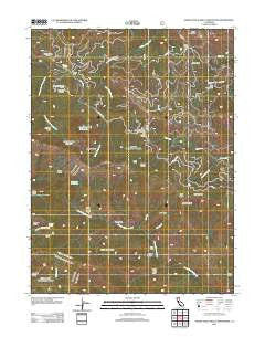
~ North Yolla Bolly Mountains CA topo map, 1:24000 scale, 7.5 X 7.5 Minute, Historical, 2012
North Yolla Bolly Mountains, California, USGS topographic map dated 2012.
Includes geographic coordinates (latitude and longitude). This topographic map is suitable for hiking, camping, and exploring, or framing it as a wall map.
Printed on-demand using high resolution imagery, on heavy weight and acid free paper, or alternatively on a variety of synthetic materials.
Topos available on paper, Waterproof, Poly, or Tyvek. Usually shipping rolled, unless combined with other folded maps in one order.
- Product Number: USGS-5630061
- Free digital map download (high-resolution, GeoPDF): North Yolla Bolly Mountains, California (file size: 26 MB)
- Map Size: please refer to the dimensions of the GeoPDF map above
- Weight (paper map): ca. 55 grams
- Map Type: POD USGS Topographic Map
- Map Series: US Topo
- Map Verison: Historical
- Cell ID: 72481
- Datum: North American Datum of 1983
- Map Projection: Transverse Mercator
- Map Cell Name: North Yolla Bolly Mountains
- Grid size: 7.5 X 7.5 Minute
- Date on map: 2012
- Map Scale: 1:24000
- Geographical region: California, United States
Neighboring Maps:
All neighboring USGS topo maps are available for sale online at a variety of scales.
Spatial coverage:
Topo map North Yolla Bolly Mountains, California, covers the geographical area associated the following places:
- Burnt Canyon - Saunders Place - East Low Gap - South Fork Cottonwood Trail - Barker Camp - Post Creek - Chicago Camp - Willow Creek - Long Ridge Trail - Beegum Basin - Long Gulch - Weston Ranch - North Yolla Bolly Cold Fork Trail - Opium Glade Ridge - Sanders Place - North Yolla Bolly Spring - Clarence Spring - Stuart Gap - Tedoc Gap - Stuart Gap Trailhead - Sanford Ridge - Wells Creek Campground - Chicago Rock - Cedar Basin - Long Ridge - North Yolla Bolly Spring - Rat Trap Ridge - Devils Hole Gulch - Dead Horse Ridge - Rat Trap Gap Trailhead Parking - Rat Trap Gap Trailhead - Deer Ridge - Rat Trap Gap - Tedoc Mountain - Grasshoppers Camp - Chicago Spring - Pettijohn Trail - Bear Gulch - North Yolla Bolly Mountains - Post Creek Guard Station - Murphy Glades - Jones Camp Creek - North Yolla Bolly Guard Station - North Yolla Bolly Lake - Fisher Ridge - Deer Creek - Van Spring Gulch - Stuart Gap Trailhead Parking - Burnt Camp - Pettijohn Basin
- Map Area ID: AREA40.2540.125-123-122.875
- Northwest corner Lat/Long code: USGSNW40.25-123
- Northeast corner Lat/Long code: USGSNE40.25-122.875
- Southwest corner Lat/Long code: USGSSW40.125-123
- Southeast corner Lat/Long code: USGSSE40.125-122.875
- Northern map edge Latitude: 40.25
- Southern map edge Latitude: 40.125
- Western map edge Longitude: -123
- Eastern map edge Longitude: -122.875


