
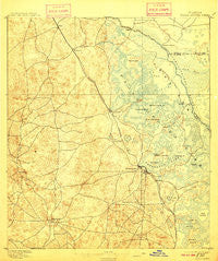
~ Tsala Apopka FL topo map, 1:62500 scale, 15 X 15 Minute, Historical, 1895, updated 1910
Tsala Apopka, Florida, USGS topographic map dated 1895.
Includes geographic coordinates (latitude and longitude). This topographic map is suitable for hiking, camping, and exploring, or framing it as a wall map.
Printed on-demand using high resolution imagery, on heavy weight and acid free paper, or alternatively on a variety of synthetic materials.
Topos available on paper, Waterproof, Poly, or Tyvek. Usually shipping rolled, unless combined with other folded maps in one order.
- Product Number: USGS-5621510
- Free digital map download (high-resolution, GeoPDF): Tsala Apopka, Florida (file size: 8 MB)
- Map Size: please refer to the dimensions of the GeoPDF map above
- Weight (paper map): ca. 55 grams
- Map Type: POD USGS Topographic Map
- Map Series: HTMC
- Map Verison: Historical
- Cell ID: 55764
- Scan ID: 348898
- Imprint Year: 1910
- Survey Year: 1893
- Datum: Unstated
- Map Projection: Unstated
- Map published by United States Geological Survey
- Map Language: English
- Scanner Resolution: 600 dpi
- Map Cell Name: Inverness
- Grid size: 15 X 15 Minute
- Date on map: 1895
- Map Scale: 1:62500
- Geographical region: Florida, United States
Neighboring Maps:
All neighboring USGS topo maps are available for sale online at a variety of scales.
Spatial coverage:
Topo map Tsala Apopka, Florida, covers the geographical area associated the following places:
- Landrum - Big Hammock (historical) - Inverness - Citrus Springs - Citrus Hills - Hernando - Lecanto - Black Diamond - Holder - Beverly Hills - Pine Ridge - Arlington
- Map Area ID: AREA2928.75-82.5-82.25
- Northwest corner Lat/Long code: USGSNW29-82.5
- Northeast corner Lat/Long code: USGSNE29-82.25
- Southwest corner Lat/Long code: USGSSW28.75-82.5
- Southeast corner Lat/Long code: USGSSE28.75-82.25
- Northern map edge Latitude: 29
- Southern map edge Latitude: 28.75
- Western map edge Longitude: -82.5
- Eastern map edge Longitude: -82.25


