
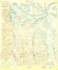
~ Citra FL topo map, 1:62500 scale, 15 X 15 Minute, Historical, 1895, updated 1909
Citra, Florida, USGS topographic map dated 1895.
Includes geographic coordinates (latitude and longitude). This topographic map is suitable for hiking, camping, and exploring, or framing it as a wall map.
Printed on-demand using high resolution imagery, on heavy weight and acid free paper, or alternatively on a variety of synthetic materials.
Topos available on paper, Waterproof, Poly, or Tyvek. Usually shipping rolled, unless combined with other folded maps in one order.
- Product Number: USGS-5621152
- Free digital map download (high-resolution, GeoPDF): Citra, Florida (file size: 7 MB)
- Map Size: please refer to the dimensions of the GeoPDF map above
- Weight (paper map): ca. 55 grams
- Map Type: POD USGS Topographic Map
- Map Series: HTMC
- Map Verison: Historical
- Cell ID: 52614
- Scan ID: 345513
- Imprint Year: 1909
- Survey Year: 1893
- Datum: Unstated
- Map Projection: Unstated
- Map published by United States Geological Survey
- Map Language: English
- Scanner Resolution: 600 dpi
- Map Cell Name: Citra
- Grid size: 15 X 15 Minute
- Date on map: 1895
- Map Scale: 1:62500
- Geographical region: Florida, United States
Neighboring Maps:
All neighboring USGS topo maps are available for sale online at a variety of scales.
Spatial coverage:
Topo map Citra, Florida, covers the geographical area associated the following places:
- McIntosh - Millwood - Villages of Ocala East Mobile Home Park - Regal Park - Martin - Oak - Orange Lake - Victory Mobile Home Park - Cross Creek - Ocala Highlands Estates - Anthony - Villages of Ocala West Mobile Home Park - Pinecrest Mobile Home Park - Zuber - Boardman - Reddick - Cyrs Mobile Home Park - Evinston - Lowell - Paynes Town (historical) - Kendrick - Citra - Burbank - Lakeside Travel Park - Sparr - Wandering Oaks Mobile Home Park - Island Grove - Ocala Park Ranch - Clifton Mobile City Mobile Home Park - Oak Mobile Home Park
- Map Area ID: AREA29.529.25-82.25-82
- Northwest corner Lat/Long code: USGSNW29.5-82.25
- Northeast corner Lat/Long code: USGSNE29.5-82
- Southwest corner Lat/Long code: USGSSW29.25-82.25
- Southeast corner Lat/Long code: USGSSE29.25-82
- Northern map edge Latitude: 29.5
- Southern map edge Latitude: 29.25
- Western map edge Longitude: -82.25
- Eastern map edge Longitude: -82


