
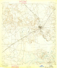
~ Arredondo FL topo map, 1:62500 scale, 15 X 15 Minute, Historical, 1892
Arredondo, Florida, USGS topographic map dated 1892.
Includes geographic coordinates (latitude and longitude). This topographic map is suitable for hiking, camping, and exploring, or framing it as a wall map.
Printed on-demand using high resolution imagery, on heavy weight and acid free paper, or alternatively on a variety of synthetic materials.
Topos available on paper, Waterproof, Poly, or Tyvek. Usually shipping rolled, unless combined with other folded maps in one order.
- Product Number: USGS-5621110
- Free digital map download (high-resolution, GeoPDF): Arredondo, Florida (file size: 5 MB)
- Map Size: please refer to the dimensions of the GeoPDF map above
- Weight (paper map): ca. 55 grams
- Map Type: POD USGS Topographic Map
- Map Series: HTMC
- Map Verison: Historical
- Cell ID: 50693
- Scan ID: 344996
- Survey Year: 1890
- Datum: Unstated
- Map Projection: Unstated
- Map published by United States Geological Survey
- Map Language: English
- Scanner Resolution: 600 dpi
- Map Cell Name: Arredono
- Grid size: 15 X 15 Minute
- Date on map: 1892
- Map Scale: 1:62500
- Geographical region: Florida, United States
Neighboring Maps:
All neighboring USGS topo maps are available for sale online at a variety of scales.
Spatial coverage:
Topo map Arredondo, Florida, covers the geographical area associated the following places:
- Melton Manor - Chantilly Acres - Alachua II (historical) - Hillcrest Mobile Home Park - Kreftwood Estates - South Idylwild - Ruthland - Gainesville - Fairbanks - Buckingham West - Idylwild - Arredondo Farms Mobile Home Park - Kincaid Hills - Green Grove - Oak Park Village Mobile Home Park - Wimberly Estates - Lakeview Estates - Tacoma - Varsity Mobile Home Villa - Beville Heights - Westgate Mobile Manor - Shadow Lawn Estates - Lincoln Estates - Suburban Heights - Clayton Estates Mobile Home Park - Rutledge - Alackaway Tolofa (historical) - Shannon Wood - Kirkwood - Robinswood - Riceland - Alamar Gardens Mobile Home Park - Westgate Manor Mobile Home Park - Arredondo - Micanopy - West Hills - Ideal Trailer Park - Robinson Heights - Paradise - Rocky Point - Arredondo Estates - Kanapaha - Candlelight Estates Mobile Home Community - Pine Hill Estates - Durant Estates - Los Trancos Woods - Malore Gardens - Brittany Estates Mobile Home Park - Wacahoota - West Park - Peach Orchard - Clinch - Northwood - Daysville
- Map Area ID: AREA29.7529.5-82.5-82.25
- Northwest corner Lat/Long code: USGSNW29.75-82.5
- Northeast corner Lat/Long code: USGSNE29.75-82.25
- Southwest corner Lat/Long code: USGSSW29.5-82.5
- Southeast corner Lat/Long code: USGSSE29.5-82.25
- Northern map edge Latitude: 29.75
- Southern map edge Latitude: 29.5
- Western map edge Longitude: -82.5
- Eastern map edge Longitude: -82.25


