
~ St George UT topo map, 1:250000 scale, 1 X 1 Degree, Historical, 1885, updated 1885
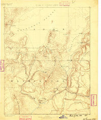
St George, Utah, USGS topographic map dated 1885.
Includes geographic coordinates (latitude and longitude). This topographic map is suitable for hiking, camping, and exploring, or framing it as a wall map.
Printed on-demand using high resolution imagery, on heavy weight and acid free paper, or alternatively on a variety of synthetic materials.
Topos available on paper, Waterproof, Poly, or Tyvek. Usually shipping rolled, unless combined with other folded maps in one order.
- Product Number: USGS-5619018
- Free digital map download (high-resolution, GeoPDF): St George, Utah (file size: 6 MB)
- Map Size: please refer to the dimensions of the GeoPDF map above
- Weight (paper map): ca. 55 grams
- Map Type: POD USGS Topographic Map
- Map Series: HTMC
- Map Verison: Historical
- Cell ID: 322245
- Scan ID: 252053
- Imprint Year: 1885
- Datum: Unstated
- Map Projection: Unstated
- Map published by United States Geological Survey
- Map Language: English
- Scanner Resolution: 600 dpi
- Map Cell Name: Cedar City W
- Grid size: 1 X 1 Degree
- Date on map: 1885
- Map Scale: 1:250000
- Geographical region: Utah, United States
Neighboring Maps:
All neighboring USGS topo maps are available for sale online at a variety of scales.
Spatial coverage:
Topo map St George, Utah, covers the geographical area associated the following places:
- Desert Mound - Anderson Junction - Bloomington Hills - Veyo - Avon - Shem - Old Irontown - Apple Valley - Modena - Santa Clara - Cedar City - Shivwits - Bloomington - Virgin Territory Trailer Park - Harrisburg Junction - Harrisburg - Big Plain Junction - Valley View Trailer Park - Gunlock - Ivins - Hurricane - Enoch - Hamlin Valley - Toquerville - Heist - Beryl Junction - Dammeron Valley - Grafton - Leeds - Yale Crossing - Virgin - LaVerkin - Saint George - Rockville - Motoqua - Kanarraville - New Harmony - Hamiltons Fort - Central - Zane - Silver Reef - Pine Valley - Iron Mountain - Beryl - Enterprise - Washington - Pintura - Newcastle - Southern Trailer Park - Middleton - Halivah - Iron Springs - Atkinville - Fort Johnson
- Map Area ID: AREA3837-114-113
- Northwest corner Lat/Long code: USGSNW38-114
- Northeast corner Lat/Long code: USGSNE38-113
- Southwest corner Lat/Long code: USGSSW37-114
- Southeast corner Lat/Long code: USGSSE37-113
- Northern map edge Latitude: 38
- Southern map edge Latitude: 37
- Western map edge Longitude: -114
- Eastern map edge Longitude: -113


