
~ Beaver UT topo map, 1:250000 scale, 1 X 1 Degree, Historical, 1885, updated 1921
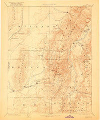
Beaver, Utah, USGS topographic map dated 1885.
Includes geographic coordinates (latitude and longitude). This topographic map is suitable for hiking, camping, and exploring, or framing it as a wall map.
Printed on-demand using high resolution imagery, on heavy weight and acid free paper, or alternatively on a variety of synthetic materials.
Topos available on paper, Waterproof, Poly, or Tyvek. Usually shipping rolled, unless combined with other folded maps in one order.
- Product Number: USGS-5618880
- Free digital map download (high-resolution, GeoPDF): Beaver, Utah (file size: 7 MB)
- Map Size: please refer to the dimensions of the GeoPDF map above
- Weight (paper map): ca. 55 grams
- Map Type: POD USGS Topographic Map
- Map Series: HTMC
- Map Verison: Historical
- Cell ID: 322258
- Scan ID: 248041
- Imprint Year: 1921
- Datum: Unstated
- Map Projection: Unstated
- Map published by United States Geological Survey
- Map Language: English
- Scanner Resolution: 600 dpi
- Map Cell Name: Richfield E
- Grid size: 1 X 1 Degree
- Date on map: 1885
- Map Scale: 1:250000
- Geographical region: Utah, United States
Neighboring Maps:
All neighboring USGS topo maps are available for sale online at a variety of scales.
Spatial coverage:
Topo map Beaver, Utah, covers the geographical area associated the following places:
- Borden - Bullion Falls - Marysvale - North Creek - Cove - Hatton - Greenville - Central Valley - Monroe - Kanosh - Gramse - Smyths - Kanosh Indian Village - Iron Basin - Hoovers - Lower Kimberly - Joseph - Cunningham Hill - Thompsonville - Beaver - Sixmile Point - Nibley - Circleville - Spry - Bone Valley - Annabella - Bloom - Sulphurdale - Sevier - Upper Kimberly - Venice - Belknap - Jensen - Kema - Murdock - Austin - Flowell - Yellow Banks - Meadow - Alunite - Minersville - Pittsburg - Black Rock - Eightmile Point - Richfield - Prattsville - Elsinore - Junction - Malone - Kingston - Fillmore - Adamsville - Read - Manderfield
- Map Area ID: AREA3938-113-112
- Northwest corner Lat/Long code: USGSNW39-113
- Northeast corner Lat/Long code: USGSNE39-112
- Southwest corner Lat/Long code: USGSSW38-113
- Southeast corner Lat/Long code: USGSSE38-112
- Northern map edge Latitude: 39
- Southern map edge Latitude: 38
- Western map edge Longitude: -113
- Eastern map edge Longitude: -112


