
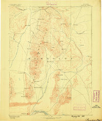
~ Paradise NV topo map, 1:250000 scale, 1 X 1 Degree, Historical, 1882
Paradise, Nevada, USGS topographic map dated 1882.
Includes geographic coordinates (latitude and longitude). This topographic map is suitable for hiking, camping, and exploring, or framing it as a wall map.
Printed on-demand using high resolution imagery, on heavy weight and acid free paper, or alternatively on a variety of synthetic materials.
Topos available on paper, Waterproof, Poly, or Tyvek. Usually shipping rolled, unless combined with other folded maps in one order.
- Product Number: USGS-5618782
- Free digital map download (high-resolution, GeoPDF): Paradise, Nevada (file size: 6 MB)
- Map Size: please refer to the dimensions of the GeoPDF map above
- Weight (paper map): ca. 55 grams
- Map Type: POD USGS Topographic Map
- Map Series: HTMC
- Map Verison: Historical
- Cell ID: 321687
- Scan ID: 321747
- Survey Year: 1882
- Datum: Unstated
- Map Projection: Unstated
- Map published by United States Geological Survey
- Map Language: English
- Scanner Resolution: 600 dpi
- Map Cell Name: McDermitt W
- Grid size: 1 X 1 Degree
- Date on map: 1882
- Map Scale: 1:250000
- Geographical region: Nevada, United States
Neighboring Maps:
All neighboring USGS topo maps are available for sale online at a variety of scales.
Spatial coverage:
Topo map Paradise, Nevada, covers the geographical area associated the following places:
- Daveytown - Kelly Creek (historical) - Cordero - Amos (historical) - Cañon Creek Station (historical) - Willow Point (historical) - Paradise Valley - Paradise Hill - Weso - Awakening - Bliss - Queen City (historical) - McDermitt - Getchell - Gouge Eye - Platora - Tule - Spring City (historical) - Rebel Creek (historical) - National (historical) - Barrett Springs (historical) - Laurel (historical) - Comus - Orovada
- Map Area ID: AREA4241-118-117
- Northwest corner Lat/Long code: USGSNW42-118
- Northeast corner Lat/Long code: USGSNE42-117
- Southwest corner Lat/Long code: USGSSW41-118
- Southeast corner Lat/Long code: USGSSE41-117
- Northern map edge Latitude: 42
- Southern map edge Latitude: 41
- Western map edge Longitude: -118
- Eastern map edge Longitude: -117


