
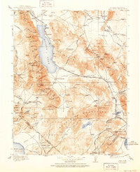
~ Hawthorne NV topo map, 1:250000 scale, 1 X 1 Degree, Historical, 1915, updated 1951
Hawthorne, Nevada, USGS topographic map dated 1915.
Includes geographic coordinates (latitude and longitude). This topographic map is suitable for hiking, camping, and exploring, or framing it as a wall map.
Printed on-demand using high resolution imagery, on heavy weight and acid free paper, or alternatively on a variety of synthetic materials.
Topos available on paper, Waterproof, Poly, or Tyvek. Usually shipping rolled, unless combined with other folded maps in one order.
- Product Number: USGS-5618740
- Free digital map download (high-resolution, GeoPDF): Hawthorne, Nevada (file size: 10 MB)
- Map Size: please refer to the dimensions of the GeoPDF map above
- Weight (paper map): ca. 55 grams
- Map Type: POD USGS Topographic Map
- Map Series: HTMC
- Map Verison: Historical
- Cell ID: 322260
- Scan ID: 321693
- Imprint Year: 1951
- Survey Year: 1909
- Datum: Unstated
- Map Projection: Polyconic
- Map published by United States Geological Survey
- Map Language: English
- Scanner Resolution: 600 dpi
- Map Cell Name: Walker Lake E
- Grid size: 1 X 1 Degree
- Date on map: 1915
- Map Scale: 1:250000
- Geographical region: Nevada, United States
Neighboring Maps:
All neighboring USGS topo maps are available for sale online at a variety of scales.
Spatial coverage:
Topo map Hawthorne, Nevada, covers the geographical area associated the following places:
- Kinkaid - Hawthorne - Bovard (historical) - Babbitt - Schurz - Basalt - Jaggersville - Sodaville - Candelaria (historical) - Rand (historical) - Schweer Housing Area - Buckley Camp (historical) - Woodruffs (historical) - Midway - Copper Hill (historical) - Candelaria Junction - Columbus - Avalon - Coryville (historical) - Rhodes (historical) - Wichman - Thorne - Copper Run - Metallic City (historical) - Belleville (historical) - Montelle (historical) - Qualeys Camp - Lucky Boy (historical) - Aurora (historical) - Fletcher - Granite (historical) - Mountain View (historical) - Walker Lake - Garfield (historical) - Acme (historical) - Copperfield (historical) - Esmeralda (historical) - Dutch Creek (historical) - Luning - Whiskey Spring (historical) - New Boston (historical) - Tonopah Junction - Camp Douglas - Marietta - Del Monte - Mina
- Map Area ID: AREA3938-119-118
- Northwest corner Lat/Long code: USGSNW39-119
- Northeast corner Lat/Long code: USGSNE39-118
- Southwest corner Lat/Long code: USGSSW38-119
- Southeast corner Lat/Long code: USGSSE38-118
- Northern map edge Latitude: 39
- Southern map edge Latitude: 38
- Western map edge Longitude: -119
- Eastern map edge Longitude: -118


