
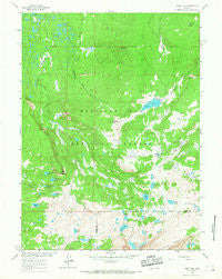
~ Sand Lake WY topo map, 1:24000 scale, 7.5 X 7.5 Minute, Historical, 1961, updated 1967
Sand Lake, Wyoming, USGS topographic map dated 1961.
Includes geographic coordinates (latitude and longitude). This topographic map is suitable for hiking, camping, and exploring, or framing it as a wall map.
Printed on-demand using high resolution imagery, on heavy weight and acid free paper, or alternatively on a variety of synthetic materials.
Topos available on paper, Waterproof, Poly, or Tyvek. Usually shipping rolled, unless combined with other folded maps in one order.
- Product Number: USGS-5615446
- Free digital map download (high-resolution, GeoPDF): Sand Lake, Wyoming (file size: 12 MB)
- Map Size: please refer to the dimensions of the GeoPDF map above
- Weight (paper map): ca. 55 grams
- Map Type: POD USGS Topographic Map
- Map Series: HTMC
- Map Verison: Historical
- Cell ID: 39763
- Scan ID: 341226
- Imprint Year: 1967
- Woodland Tint: Yes
- Aerial Photo Year: 1958
- Field Check Year: 1961
- Datum: NAD27
- Map Projection: Polyconic
- Map published by United States Geological Survey
- Map Language: English
- Scanner Resolution: 600 dpi
- Map Cell Name: Sand Lake
- Grid size: 7.5 X 7.5 Minute
- Date on map: 1961
- Map Scale: 1:24000
- Geographical region: Wyoming, United States
Neighboring Maps:
All neighboring USGS topo maps are available for sale online at a variety of scales.
Spatial coverage:
Topo map Sand Lake, Wyoming, covers the geographical area associated the following places:
- Bow River Observation Site - Sand Lake - Waterloo Prospect - Windy Hill - Vagner Lake - Johnson Park - Jeff Lake - Corral Lake - Upper Long Lake - Edwards Lake - Arrowhead Lake - Meadows Lakes - Golden Crown Mining Syndicate Mine - Mutt Lake - Lookout Mountain - Corpening Reservoir - Cutthoat Lake - Deep Lake - Pine Butte - Crescent Lake - North Gap Lake - Shelf Lakes - South Banner Lake - Sand Lake Lodge - Grassy Lake - Reservoir Lake - Corpening Dam - Drillers Lake - Bow River Overlook - Cascade Lake - Little Long Lake - Deep Creek Campground - Quealy Lake - Black Spotted Lake - Vosseller Lake - Wheatland Reservoir Dam - East Banner Lake - Carlson Park Guard Station - North Banner Lake - Stillwater Park - Campbell Lake - Carlson Park - Sheep Lake - Glacier Lakes - Sand Lake Reservoir
- Map Area ID: AREA41.541.375-106.375-106.25
- Northwest corner Lat/Long code: USGSNW41.5-106.375
- Northeast corner Lat/Long code: USGSNE41.5-106.25
- Southwest corner Lat/Long code: USGSSW41.375-106.375
- Southeast corner Lat/Long code: USGSSE41.375-106.25
- Northern map edge Latitude: 41.5
- Southern map edge Latitude: 41.375
- Western map edge Longitude: -106.375
- Eastern map edge Longitude: -106.25


