
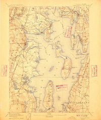
~ Narragansett Bay RI topo map, 1:62500 scale, 15 X 15 Minute, Historical, 1892, updated 1910
Narragansett Bay, Rhode Island, USGS topographic map dated 1892.
Includes geographic coordinates (latitude and longitude). This topographic map is suitable for hiking, camping, and exploring, or framing it as a wall map.
Printed on-demand using high resolution imagery, on heavy weight and acid free paper, or alternatively on a variety of synthetic materials.
Topos available on paper, Waterproof, Poly, or Tyvek. Usually shipping rolled, unless combined with other folded maps in one order.
- Product Number: USGS-5604556
- Free digital map download (high-resolution, GeoPDF): Narragansett Bay, Rhode Island (file size: 8 MB)
- Map Size: please refer to the dimensions of the GeoPDF map above
- Weight (paper map): ca. 55 grams
- Map Type: POD USGS Topographic Map
- Map Series: HTMC
- Map Verison: Historical
- Cell ID: 58272
- Scan ID: 353506
- Imprint Year: 1910
- Survey Year: 1888
- Datum: Unstated
- Map Projection: Unstated
- Map published by United States Geological Survey
- Map Language: English
- Scanner Resolution: 600 dpi
- Map Cell Name: Narrangansett Bay
- Grid size: 15 X 15 Minute
- Date on map: 1892
- Map Scale: 1:62500
- Geographical region: Rhode Island, United States
Neighboring Maps:
All neighboring USGS topo maps are available for sale online at a variety of scales.
Spatial coverage:
Topo map Narragansett Bay, Rhode Island, covers the geographical area associated the following places:
- Pontiac - Shady Lea - Nichols Corner - Thatch Cove (historical) - Westcott - Lockwood Corner - Plum Beach - Bartons Corner - Portsmouth - Bayside - Quidnessett - Annawomscutt - Apponaug - Buttonwoods - North Quidnessett - Hamilton - Bristol Highlands - Cowesett - Highland Beach - Prudence Park - Conimicut - Jamestown Shores - Meadow View - Lincoln Park - Spring Green - Palace Garden - Nausauket - Lawtons - Longmeadow - Greenwood - Crossways (historical) - West Barrington - Beach Terrace - Rocky Point - Wildes Corner - Frys Corner - River View - Shawomet - East Natick - Shore Acres - Laurel Park - Kettle Corner - Natick - Frenchtown - Bristol Ferry - Wickford Junction - Cold Spring Beach - Barrington - Allenton - Sowams (historical) - Lafayette - Congdon Hill (historical) - Annaquatucket - Bristol Township - Mount View - Howard - Bristol - Plum Point - Folly Landing - Kiefer Park - Old Buttonwoods - Conanicut Park - Whitehall - Hoxsie - Belleville - South Portsmouth - Wickford - Potowomut - Pocasset Heights - Middletown - North Kingstown - Narragansett Terrace - Nag Creek - Davisville - Oakland Beach - East Greenwich - Nayatt - Hillsgrove - Saunderstown - East Warren - Maxfields Corner - Bay Spring - Warwick - Old Warwick - Coles - Chepiwanoxet - Homestead - Paradise Mobile Home Park - Warren - Cocumscussoc (historical) - Melville
- Map Area ID: AREA41.7541.5-71.5-71.25
- Northwest corner Lat/Long code: USGSNW41.75-71.5
- Northeast corner Lat/Long code: USGSNE41.75-71.25
- Southwest corner Lat/Long code: USGSSW41.5-71.5
- Southeast corner Lat/Long code: USGSSE41.5-71.25
- Northern map edge Latitude: 41.75
- Southern map edge Latitude: 41.5
- Western map edge Longitude: -71.5
- Eastern map edge Longitude: -71.25


