
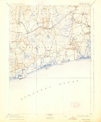
~ Charlestown RI topo map, 1:62500 scale, 15 X 15 Minute, Historical, 1889, updated 1926
Charlestown, Rhode Island, USGS topographic map dated 1889.
Includes geographic coordinates (latitude and longitude). This topographic map is suitable for hiking, camping, and exploring, or framing it as a wall map.
Printed on-demand using high resolution imagery, on heavy weight and acid free paper, or alternatively on a variety of synthetic materials.
Topos available on paper, Waterproof, Poly, or Tyvek. Usually shipping rolled, unless combined with other folded maps in one order.
- Product Number: USGS-5604528
- Free digital map download (high-resolution, GeoPDF): Charlestown, Rhode Island (file size: 6 MB)
- Map Size: please refer to the dimensions of the GeoPDF map above
- Weight (paper map): ca. 55 grams
- Map Type: POD USGS Topographic Map
- Map Series: HTMC
- Map Verison: Historical
- Cell ID: 52419
- Scan ID: 353492
- Imprint Year: 1926
- Survey Year: 1888
- Datum: NAD
- Map Projection: Polyconic
- Map published by United States Geological Survey
- Map Language: English
- Scanner Resolution: 600 dpi
- Map Cell Name: Charlestown
- Grid size: 15 X 15 Minute
- Date on map: 1889
- Map Scale: 1:62500
- Geographical region: Rhode Island, United States
Neighboring Maps:
All neighboring USGS topo maps are available for sale online at a variety of scales.
Spatial coverage:
Topo map Charlestown, Rhode Island, covers the geographical area associated the following places:
- Shelter Harbor - Kenyon - Burdickville - Columbia Heights - Shannock - Gould - Wood River Junction - Galilee - Charlestown - Perryville - Alton - Matunuck - Shady Harbor - Bradford - Tuckertown Four Corners - Rocky Brook - Kingston Station - Charlestown Beach - Tuckertown - West Kingston - Green Hill - Wakefield - Ellis Flats - Quonochontaug Beach (historical) - Arnolda - Curtis Corner - Canonchet - Quonochontaug - Snug Harbor - Kingston - Brudickville - Haversham - Woodville - Fort Ninigret - Jerusalem - Carolina
- Map Area ID: AREA41.541.25-71.75-71.5
- Northwest corner Lat/Long code: USGSNW41.5-71.75
- Northeast corner Lat/Long code: USGSNE41.5-71.5
- Southwest corner Lat/Long code: USGSSW41.25-71.75
- Southeast corner Lat/Long code: USGSSE41.25-71.5
- Northern map edge Latitude: 41.5
- Southern map edge Latitude: 41.25
- Western map edge Longitude: -71.75
- Eastern map edge Longitude: -71.5


