
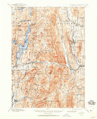
~ Castleton VT topo map, 1:62500 scale, 15 X 15 Minute, Historical, 1895, updated 1960
Castleton, Vermont, USGS topographic map dated 1895.
Includes geographic coordinates (latitude and longitude). This topographic map is suitable for hiking, camping, and exploring, or framing it as a wall map.
Printed on-demand using high resolution imagery, on heavy weight and acid free paper, or alternatively on a variety of synthetic materials.
Topos available on paper, Waterproof, Poly, or Tyvek. Usually shipping rolled, unless combined with other folded maps in one order.
- Product Number: USGS-5600220
- Free digital map download (high-resolution, GeoPDF): Castleton, Vermont (file size: 12 MB)
- Map Size: please refer to the dimensions of the GeoPDF map above
- Weight (paper map): ca. 55 grams
- Map Type: POD USGS Topographic Map
- Map Series: HTMC
- Map Verison: Historical
- Cell ID: 52266
- Scan ID: 337921
- Imprint Year: 1960
- Survey Year: 1895
- Datum: NAD27
- Map Projection: Polyconic
- Map published by United States Geological Survey
- Map Language: English
- Scanner Resolution: 600 dpi
- Map Cell Name: Castleton
- Grid size: 15 X 15 Minute
- Date on map: 1895
- Map Scale: 1:62500
- Geographical region: Vermont, United States
Neighboring Maps:
All neighboring USGS topo maps are available for sale online at a variety of scales.
Spatial coverage:
Topo map Castleton, Vermont, covers the geographical area associated the following places:
- West Rutland - Hydeville - Durgy Hill Heights - East Hubbardton - Castleton - Hubbardton - Crystal Beach - West Castleton - Castleton Corners - Florence - Poultney - Grangerville - Hortonia - Point of Pines - Proctor - Gorhamtown - Neshobe Beach - Blissville - Center Rutland - Ira - Chippenhook - Bomoseen - Avalon Beach - Ransomvale - East Poultney - Pittsford - Clarendon Springs
- Map Area ID: AREA43.7543.5-73.25-73
- Northwest corner Lat/Long code: USGSNW43.75-73.25
- Northeast corner Lat/Long code: USGSNE43.75-73
- Southwest corner Lat/Long code: USGSSW43.5-73.25
- Southeast corner Lat/Long code: USGSSE43.5-73
- Northern map edge Latitude: 43.75
- Southern map edge Latitude: 43.5
- Western map edge Longitude: -73.25
- Eastern map edge Longitude: -73


