
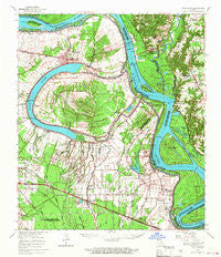
~ New Roads LA topo map, 1:62500 scale, 15 X 15 Minute, Historical, 1963, updated 1967
New Roads, Louisiana, USGS topographic map dated 1963.
Includes geographic coordinates (latitude and longitude). This topographic map is suitable for hiking, camping, and exploring, or framing it as a wall map.
Printed on-demand using high resolution imagery, on heavy weight and acid free paper, or alternatively on a variety of synthetic materials.
Topos available on paper, Waterproof, Poly, or Tyvek. Usually shipping rolled, unless combined with other folded maps in one order.
- Product Number: USGS-5594570
- Free digital map download (high-resolution, GeoPDF): New Roads, Louisiana (file size: 9 MB)
- Map Size: please refer to the dimensions of the GeoPDF map above
- Weight (paper map): ca. 55 grams
- Map Type: POD USGS Topographic Map
- Map Series: HTMC
- Map Verison: Historical
- Cell ID: 58386
- Scan ID: 334867
- Imprint Year: 1967
- Woodland Tint: Yes
- Datum: NAD27
- Map Projection: Polyconic
- Map published by United States Geological Survey
- Map Language: English
- Scanner Resolution: 600 dpi
- Map Cell Name: New Roads
- Grid size: 15 X 15 Minute
- Date on map: 1963
- Map Scale: 1:62500
- Geographical region: Louisiana, United States
Neighboring Maps:
All neighboring USGS topo maps are available for sale online at a variety of scales.
Spatial coverage:
Topo map New Roads, Louisiana, covers the geographical area associated the following places:
- New Roads - Anchor - Bueche - Pointe Coupee - Brooks - Leavel - Knapp - Patin - Rose Hill (historical) - Mix - Glynn - Wickliffe - Walls - Lakeland - Oscar - Basel (historical) - Devalls - Ploup - Arbroth - Mount Pleasant - Oakland - Chenal - Ted Davis Mobile Home Park - Jarreau - Beaud - Alfords - Majors - Shexnayder - Delombre - Carey - Powell - Paloma (historical) - Ventress - Allon - Port Jackson (historical) - Torbert - Dupont - Riddle - Dugan Landing - Seibert (historical) - Barroza (historical) - Saint Dizier - Mannheim (historical) - Rougon - Waterloo - Port Hudson - Chenal Crossing - Bonn - Port Hickey - Smithfield - Yattan - Ingleside - Parlange - Allen Landing - Erwinville - Chamberlin - Alma - Island - Hermitage - Port Hickey Landing
- Map Area ID: AREA30.7530.5-91.5-91.25
- Northwest corner Lat/Long code: USGSNW30.75-91.5
- Northeast corner Lat/Long code: USGSNE30.75-91.25
- Southwest corner Lat/Long code: USGSSW30.5-91.5
- Southeast corner Lat/Long code: USGSSE30.5-91.25
- Northern map edge Latitude: 30.75
- Southern map edge Latitude: 30.5
- Western map edge Longitude: -91.5
- Eastern map edge Longitude: -91.25


