
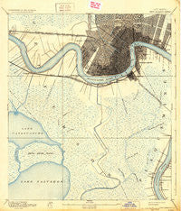
~ New Orleans LA topo map, 1:62500 scale, 15 X 15 Minute, Historical, 1891, updated 1931
New Orleans, Louisiana, USGS topographic map dated 1891.
Includes geographic coordinates (latitude and longitude). This topographic map is suitable for hiking, camping, and exploring, or framing it as a wall map.
Printed on-demand using high resolution imagery, on heavy weight and acid free paper, or alternatively on a variety of synthetic materials.
Topos available on paper, Waterproof, Poly, or Tyvek. Usually shipping rolled, unless combined with other folded maps in one order.
- Product Number: USGS-5594562
- Free digital map download (high-resolution, GeoPDF): New Orleans, Louisiana (file size: 8 MB)
- Map Size: please refer to the dimensions of the GeoPDF map above
- Weight (paper map): ca. 55 grams
- Map Type: POD USGS Topographic Map
- Map Series: HTMC
- Map Verison: Historical
- Cell ID: 58380
- Scan ID: 334863
- Imprint Year: 1931
- Survey Year: 1890
- Datum: Unstated
- Map Projection: Polyconic
- Map published by United States Geological Survey
- Map Language: English
- Scanner Resolution: 600 dpi
- Map Cell Name: New Orleans
- Grid size: 15 X 15 Minute
- Date on map: 1891
- Map Scale: 1:62500
- Geographical region: Louisiana, United States
Neighboring Maps:
All neighboring USGS topo maps are available for sale online at a variety of scales.
Spatial coverage:
Topo map New Orleans, Louisiana, covers the geographical area associated the following places:
- Woodlawn - New Orleans - Oakville - Metairie Terrace - Farmington Place - Greenville - Waggaman - Lafayette (historical) - Timberlane - Bayou Cane - Andrus Mobile Home Park - Carrollton - Concession - Cedar Grove - Justice Trailer Court - Shrewsbury - Terrytown - Hassel's Trailer Park - Harvey - Faubourg Marigny - Greenwood - Walkertown - Jefferson - Garden District - Augusta - H and D Mobile Home Park - Jefferson Heights - Pricetown (historical) - Breaux Mobile Home Park - Kennedy Heights - Harahan - River Ridge - Willswood - Majorias Many Trees Mobile Home Park - Arabi - Metairie - Storyville - Bridge City - Westwego - Promised Land - Elmwood - Orlandos Mobile Home Park - Woodmere - Estelle - Circle West Mobile Homes Estates - Live Oak Manor - McDonoghville - Kenner - Bellemeade - Harahan Junction - Lower Garden District - Lakewood Country Club Estates - Crown Point - Place De Concorde - Marrero - Sievers Trailer Court - Vieux Carre - Rex Trailer Court - Little Farms (historical) - Gretna - Live Oak - Algiers - Bonnabel Place - Southport - Oak Ridge Park - Oak Park II Mobile Home Park - Bertrandville - Linwood - Sarah - Beverly Knoll - Avondale
- Map Area ID: AREA3029.75-90.25-90
- Northwest corner Lat/Long code: USGSNW30-90.25
- Northeast corner Lat/Long code: USGSNE30-90
- Southwest corner Lat/Long code: USGSSW29.75-90.25
- Southeast corner Lat/Long code: USGSSE29.75-90
- Northern map edge Latitude: 30
- Southern map edge Latitude: 29.75
- Western map edge Longitude: -90.25
- Eastern map edge Longitude: -90


