
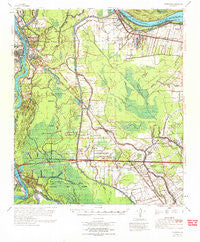
~ Fordoche LA topo map, 1:62500 scale, 15 X 15 Minute, Historical, 1970, updated 1972
Fordoche, Louisiana, USGS topographic map dated 1970.
Includes geographic coordinates (latitude and longitude). This topographic map is suitable for hiking, camping, and exploring, or framing it as a wall map.
Printed on-demand using high resolution imagery, on heavy weight and acid free paper, or alternatively on a variety of synthetic materials.
Topos available on paper, Waterproof, Poly, or Tyvek. Usually shipping rolled, unless combined with other folded maps in one order.
- Product Number: USGS-5594030
- Free digital map download (high-resolution, GeoPDF): Fordoche, Louisiana (file size: 9 MB)
- Map Size: please refer to the dimensions of the GeoPDF map above
- Weight (paper map): ca. 55 grams
- Map Type: POD USGS Topographic Map
- Map Series: HTMC
- Map Verison: Historical
- Cell ID: 54231
- Scan ID: 334549
- Imprint Year: 1972
- Woodland Tint: Yes
- Aerial Photo Year: 1966
- Datum: NAD27
- Map Projection: Polyconic
- Map published by United States Army Corps of Engineers
- Map Language: English
- Scanner Resolution: 600 dpi
- Map Cell Name: Fordoche
- Grid size: 15 X 15 Minute
- Date on map: 1970
- Map Scale: 1:62500
- Geographical region: Louisiana, United States
Neighboring Maps:
All neighboring USGS topo maps are available for sale online at a variety of scales.
Spatial coverage:
Topo map Fordoche, Louisiana, covers the geographical area associated the following places:
- Valverda - Blanks - False River - Argyle - Morganza - Frisco - Brownview - Viva - Lottie - Labarre - Morrison - Zugg (historical) - Morganza Landing - Kelsey - Ravenswood - Livonia - Stewart Plantation - Quick - Stonewell Plantation - Melville - Frogmore - Aline - Angeles Plantation - Brunswick Plantation - Argyle Plantation - Samuels - Sherburne - Fordoche - Elliot City (historical) - Kenmore - Dawson Switch
- Map Area ID: AREA30.7530.5-91.75-91.5
- Northwest corner Lat/Long code: USGSNW30.75-91.75
- Northeast corner Lat/Long code: USGSNE30.75-91.5
- Southwest corner Lat/Long code: USGSSW30.5-91.75
- Southeast corner Lat/Long code: USGSSE30.5-91.5
- Northern map edge Latitude: 30.75
- Southern map edge Latitude: 30.5
- Western map edge Longitude: -91.75
- Eastern map edge Longitude: -91.5


