
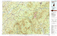
~ Mount Washington NH topo map, 1:100000 scale, 30 X 60 Minute, Historical, 1988, updated 1989
Mount Washington, New Hampshire, USGS topographic map dated 1988.
Includes geographic coordinates (latitude and longitude). This topographic map is suitable for hiking, camping, and exploring, or framing it as a wall map.
Printed on-demand using high resolution imagery, on heavy weight and acid free paper, or alternatively on a variety of synthetic materials.
Topos available on paper, Waterproof, Poly, or Tyvek. Usually shipping rolled, unless combined with other folded maps in one order.
- Product Number: USGS-5583984
- Free digital map download (high-resolution, GeoPDF): Mount Washington, New Hampshire (file size: 38 MB)
- Map Size: please refer to the dimensions of the GeoPDF map above
- Weight (paper map): ca. 55 grams
- Map Type: POD USGS Topographic Map
- Map Series: HTMC
- Map Verison: Historical
- Cell ID: 68011
- Scan ID: 330410
- Imprint Year: 1989
- Woodland Tint: Yes
- Aerial Photo Year: 1986
- Edit Year: 1988
- Datum: NAD27
- Map Projection: Universal Transverse Mercator
- Map published by United States Geological Survey
- Map Language: English
- Scanner Resolution: 600 dpi
- Map Cell Name: Mount Washington
- Grid size: 30 X 60 Minute
- Date on map: 1988
- Map Scale: 1:100000
- Geographical region: New Hampshire, United States
Neighboring Maps:
All neighboring USGS topo maps are available for sale online at a variety of scales.
Spatial coverage:
Topo map Mount Washington, New Hampshire, covers the geographical area associated the following places:
- Landaff Center - Baptist Hill - Gateway Trailer Park - North Conway - Quebec Junction - Cooks Crossing - Benton - Whitefield - North Chatham - Bowman - Concord - Scates Corner - Pierce Bridge - East Haverhill - Lunenburg - Redstone - Upper Village - Bethlehem - Nutter - Apthorp - Wildwood - North Littleton - Newtons Mobile Park - Twin Mountain - Rim Junction - North Concord - Randolph - Brickett Place - Chatham - Bretton Woods - Scott - Lower Waterford - Lost River - Grange - Bath - Barrett - Ireland - Mittersill - Stillwater - Waumbeck Junction - Fabyan - Highlands - South Chatham - Notchland - Jackson - The Village of Loon Mountain - Intervale - Cushman - Berlin - Maplewood - Gilman Mobile Park - Gilman - Goodrich Falls - Fairview - Parker Hill - Lower Bartlett - Bartlett - Ducks Head - West Bath - Marshfield Station - Dalton - Franconia - Littleton - Jockey Hill - Deerfield - Lisbon - Gorham - Sawyers River - Coreys Mobile Park - Hazens - Concord Corner - Swiftwater - Tinkerville - Panno Place - Sugar Hill - South Lunenburg - Rogers Crossing - Starr King - Glen - South Lancaster - Randolph Hill - Appalachia - Kearsarge - Savageville - Jefferson Highland - Mill Village - Center Haverhill - Lancaster - East Concord - Easton - Whites Corner - South Kirby - Upper Village - Jericho - Mountain Lakes - Cascade - Pettyboro - Black Mountain Cabin - Miles Pond - Carroll
- Map Area ID: AREA44.544-72-71
- Northwest corner Lat/Long code: USGSNW44.5-72
- Northeast corner Lat/Long code: USGSNE44.5-71
- Southwest corner Lat/Long code: USGSSW44-72
- Southeast corner Lat/Long code: USGSSE44-71
- Northern map edge Latitude: 44.5
- Southern map edge Latitude: 44
- Western map edge Longitude: -72
- Eastern map edge Longitude: -71


