
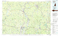
~ Keene NH topo map, 1:100000 scale, 30 X 60 Minute, Historical, 1986, updated 1986
Keene, New Hampshire, USGS topographic map dated 1986.
Includes geographic coordinates (latitude and longitude). This topographic map is suitable for hiking, camping, and exploring, or framing it as a wall map.
Printed on-demand using high resolution imagery, on heavy weight and acid free paper, or alternatively on a variety of synthetic materials.
Topos available on paper, Waterproof, Poly, or Tyvek. Usually shipping rolled, unless combined with other folded maps in one order.
- Product Number: USGS-5583976
- Free digital map download (high-resolution, GeoPDF): Keene, New Hampshire (file size: 23 MB)
- Map Size: please refer to the dimensions of the GeoPDF map above
- Weight (paper map): ca. 55 grams
- Map Type: POD USGS Topographic Map
- Map Series: HTMC
- Map Verison: Historical
- Cell ID: 67752
- Scan ID: 330406
- Imprint Year: 1986
- Woodland Tint: Yes
- Aerial Photo Year: 1983
- Edit Year: 1986
- Datum: NAD27
- Map Projection: Universal Transverse Mercator
- Planimetric: Yes
- Map published by United States Geological Survey
- Map Language: English
- Scanner Resolution: 600 dpi
- Map Cell Name: Keene
- Grid size: 30 X 60 Minute
- Date on map: 1986
- Map Scale: 1:100000
- Geographical region: New Hampshire, United States
Neighboring Maps:
All neighboring USGS topo maps are available for sale online at a variety of scales.
Spatial coverage:
Topo map Keene, New Hampshire, covers the geographical area associated the following places:
- Phillipston - Bowkerville - Goose City - King Corner - Waterville - West Leyden - South Royalston - Mountain Home Trailer Park - Camp Notre Dame - Partridgeville - New Salem - Tanglewood Estates - Bernardston - Wendell Depot - Ashfield - Mount Hermon - Winchester - Vernon - Mount Hermon Station - Algiers (historical) - Winchendon Springs - South Vernon - South Keene - South Athol - Chesham - North Bernardston - Heartwellville - Somerset - Glenallen - Westmoreland - West Rindge - Turners Falls - Dodge Corner - Wendell - North New Salem - Partridgeville - West Halifax - Camp Rowe - Northfield - Pinedale - Hales Crossing - Monroe Bridge - Rand - Halifax - Camp Caravan - North Swanzey - Jones Corner - Dummerston Center - Guilford Center - West Hawley - Putney - East Dummerston - Swanzey - Conway - Thomas - Marlboro - Adamsville - Partidgeville - Baptist Corners - Munns Ferry - North Sunderland - North Orange - Curtis Corner - Roxbury Center - Jacksonville - Cold Spring - Watson - Hillside Acres Mobile Home Park - Locks Village - Montague - West Northfield - Deerfield - Bardwell - Gilboa - Swanzey Station - North Leverett - Eastview - Blissville - Bullardville - Camp Forest Lake - Pitcherville - Fitzwilliam - North Richmond - Morse Village - Dover - Newfane - Rindge - West Deerfield - Marlborough - Richmond - Chesterfield - Neale Place - Parkers Station - Zoar - Hawley - Rockwood - Harrisville - Athol - Pequoig - Dublin
- Map Area ID: AREA4342.5-73-72
- Northwest corner Lat/Long code: USGSNW43-73
- Northeast corner Lat/Long code: USGSNE43-72
- Southwest corner Lat/Long code: USGSSW42.5-73
- Southeast corner Lat/Long code: USGSSE42.5-72
- Northern map edge Latitude: 43
- Southern map edge Latitude: 42.5
- Western map edge Longitude: -73
- Eastern map edge Longitude: -72


