
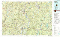
~ Keene NH topo map, 1:100000 scale, 30 X 60 Minute, Historical, 1986, updated 1988
Keene, New Hampshire, USGS topographic map dated 1986.
Includes geographic coordinates (latitude and longitude). This topographic map is suitable for hiking, camping, and exploring, or framing it as a wall map.
Printed on-demand using high resolution imagery, on heavy weight and acid free paper, or alternatively on a variety of synthetic materials.
Topos available on paper, Waterproof, Poly, or Tyvek. Usually shipping rolled, unless combined with other folded maps in one order.
- Product Number: USGS-5583974
- Free digital map download (high-resolution, GeoPDF): Keene, New Hampshire (file size: 34 MB)
- Map Size: please refer to the dimensions of the GeoPDF map above
- Weight (paper map): ca. 55 grams
- Map Type: POD USGS Topographic Map
- Map Series: HTMC
- Map Verison: Historical
- Cell ID: 67752
- Scan ID: 330405
- Imprint Year: 1988
- Woodland Tint: Yes
- Aerial Photo Year: 1983
- Edit Year: 1986
- Datum: NAD27
- Map Projection: Universal Transverse Mercator
- Map published by United States Geological Survey
- Map Language: English
- Scanner Resolution: 600 dpi
- Map Cell Name: Keene
- Grid size: 30 X 60 Minute
- Date on map: 1986
- Map Scale: 1:100000
- Geographical region: New Hampshire, United States
Neighboring Maps:
All neighboring USGS topo maps are available for sale online at a variety of scales.
Spatial coverage:
Topo map Keene, New Hampshire, covers the geographical area associated the following places:
- North Swanzey - Burrage Corner - Wilmington - Greenfield - Gill - Montague City - Nelson - Shirkshire - Rockwood - Royalston - West Northfield - Turners Falls - Northfield Farms - West Dover - Harper Acres - Griswoldville - The Street - Mill River - Pitcherville - Mountain Home Trailer Park - West Swanzey - Dummerston Center - Hallockville - Pinedale - Rowe - Eaglesville - Baptist Corner - Bardwell - Buckland - Spofford - Guilford - Jones Corner - Templeton Station - Shattuckville - Shelburne - Guilford Center - Chesterfield - Brattleboro - Marlboro - Farley - Plainfield - Reid Hollow - Lake Pleasant - South Wendell - North Hinsdale - King Corner - Colrain - Partidgeville - Gilboa - Baldwinville - Cold Spring - Northfield - Tanglewood Estates - West Hawley - Vernon - Drury - Fitzwilliam - Whitneyville - Longmeadow Subdivision - Grove - Newfane - Lyonsville - Neale Place - Ames Hill - Factory Village (historical) - State Line - Waterville - Millers Falls - Dublin - Partridgeville - West Orange - Williamsville Station - Rand - Wendell - Beldingville - Glenallen - East Greenfield - Stewartville - Keene - The Patten - Parkers Station - Blissville - Partridgeville - West Guilford - Spragueville - Orange - Burkville - Swanzey - East Charlemont - North Heath - Roxbury Center - North Sunderland - Putney - North Orange - Tully - Woodmere - Halifax - South Hawley - Satans Kingdom - West Leyden
- Map Area ID: AREA4342.5-73-72
- Northwest corner Lat/Long code: USGSNW43-73
- Northeast corner Lat/Long code: USGSNE43-72
- Southwest corner Lat/Long code: USGSSW42.5-73
- Southeast corner Lat/Long code: USGSSE42.5-72
- Northern map edge Latitude: 43
- Southern map edge Latitude: 42.5
- Western map edge Longitude: -73
- Eastern map edge Longitude: -72


