
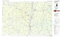
~ Claremont NH topo map, 1:100000 scale, 30 X 60 Minute, Historical, 1985, updated 1986
Claremont, New Hampshire, USGS topographic map dated 1985.
Includes geographic coordinates (latitude and longitude). This topographic map is suitable for hiking, camping, and exploring, or framing it as a wall map.
Printed on-demand using high resolution imagery, on heavy weight and acid free paper, or alternatively on a variety of synthetic materials.
Topos available on paper, Waterproof, Poly, or Tyvek. Usually shipping rolled, unless combined with other folded maps in one order.
- Product Number: USGS-5583964
- Free digital map download (high-resolution, GeoPDF): Claremont, New Hampshire (file size: 20 MB)
- Map Size: please refer to the dimensions of the GeoPDF map above
- Weight (paper map): ca. 55 grams
- Map Type: POD USGS Topographic Map
- Map Series: HTMC
- Map Verison: Historical
- Cell ID: 67300
- Scan ID: 330400
- Imprint Year: 1986
- Woodland Tint: Yes
- Visual Version Number: 1
- Aerial Photo Year: 1983
- Edit Year: 1985
- Datum: NAD27
- Map Projection: Universal Transverse Mercator
- Planimetric: Yes
- Map published by United States Geological Survey
- Map Language: English
- Scanner Resolution: 600 dpi
- Map Cell Name: Claremont
- Grid size: 30 X 60 Minute
- Date on map: 1985
- Map Scale: 1:100000
- Geographical region: New Hampshire, United States
Neighboring Maps:
All neighboring USGS topo maps are available for sale online at a variety of scales.
Spatial coverage:
Topo map Claremont, New Hampshire, covers the geographical area associated the following places:
- Springfield Junction - Cornish Flat - Weathersfield Bow - Simonsville - Goshen - Puckershire - Landgrove Town Center - Loverens Mill - Cambridgeport - Townshend - Proctorsville - Mount Holly - South Reading - Sullivan - Bondville - Unity - West Claremont - Munsonville - Crescent Lake - French Hollow - North Springfield - Middletown - Belmont - Snumshire - Burkehaven - East Lempster - Stratton Mountain - Bellows Falls - Westminster Station - Pikes Falls - Intervale - Bromley Village - Rockingham - Ryder Corner - Stocker Acres - Chester - Langdon - Westminster West - Tarbellville - Baltimore - Rawsonville - Wardsboro - East Acworth - Stoddard - Shaws Corner - Trapshire - Stratton - West Townshend - Christian Hollow - Claremont - Hastings - Westmoreland Depot - Gee Mill - The Island - Ludlow - Grafton - Timber Hill Estates - South End - South Londonderry - Acworth - Hortonville - Granliden - Cavendish - North Landgrove - Baker Corner - West Unity - Charlestown - Croydon Flat - East Wallingford - Baileys Mills - Goulds Mill - Cornish Center - Quaker City - East Unity - South Charlestown - Grahamsville - Newport - Simpsonville - West Springfield - East Washington - Cornish City - Mill Hollow - Peru - Cavendish Center - Kelleyville - Smithville - Wardsboro Center - North Westminster - Sherwood Forest - Drewsville - Harmonyville - Danby - Georges Mills - Reedville - Alstead Center - Marlow Junction - Tyson - Gilsum - Gassetts - Saxtons River
- Map Area ID: AREA43.543-73-72
- Northwest corner Lat/Long code: USGSNW43.5-73
- Northeast corner Lat/Long code: USGSNE43.5-72
- Southwest corner Lat/Long code: USGSSW43-73
- Southeast corner Lat/Long code: USGSSE43-72
- Northern map edge Latitude: 43.5
- Southern map edge Latitude: 43
- Western map edge Longitude: -73
- Eastern map edge Longitude: -72


