
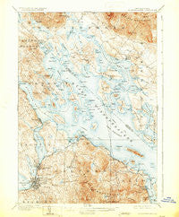
~ Winnepesaukee NH topo map, 1:62500 scale, 15 X 15 Minute, Historical, 1909, updated 1931
Winnepesaukee, New Hampshire, USGS topographic map dated 1909.
Includes geographic coordinates (latitude and longitude). This topographic map is suitable for hiking, camping, and exploring, or framing it as a wall map.
Printed on-demand using high resolution imagery, on heavy weight and acid free paper, or alternatively on a variety of synthetic materials.
Topos available on paper, Waterproof, Poly, or Tyvek. Usually shipping rolled, unless combined with other folded maps in one order.
- Product Number: USGS-5583926
- Free digital map download (high-resolution, GeoPDF): Winnepesaukee, New Hampshire (file size: 11 MB)
- Map Size: please refer to the dimensions of the GeoPDF map above
- Weight (paper map): ca. 55 grams
- Map Type: POD USGS Topographic Map
- Map Series: HTMC
- Map Verison: Historical
- Cell ID: 64632
- Scan ID: 330381
- Imprint Year: 1931
- Survey Year: 1907
- Datum: NAD
- Map Projection: Polyconic
- Map published by United States Geological Survey
- Map Language: English
- Scanner Resolution: 600 dpi
- Map Cell Name: Winnipesaukee
- Grid size: 15 X 15 Minute
- Date on map: 1909
- Map Scale: 1:62500
- Geographical region: New Hampshire, United States
Neighboring Maps:
All neighboring USGS topo maps are available for sale online at a variety of scales.
Spatial coverage:
Topo map Winnepesaukee, New Hampshire, covers the geographical area associated the following places:
- Lake Shore Park - Interlaken Park - Lakeport - Ames - Dockham Shore - Spring Haven - East Bear Island - Keewayden - Clark Landing - Wildwood Village - The Ledges - Lovejoy Sands - Laconia - Glendale - Brookhurst - Woodlands - Union Wharf - Center Harbor - Samoset - Mirror Lake - Bear Island - Wawbeek - Moultonborough Falls - West Alton - Pendleton Beach - Winnipesaukee - Mount Major - Melvin Village - Leavitt Park - Gilford - Mallard Cove - Yale Estates - Lees Mill - State Landing - Weirs Beach
- Map Area ID: AREA43.7543.5-71.5-71.25
- Northwest corner Lat/Long code: USGSNW43.75-71.5
- Northeast corner Lat/Long code: USGSNE43.75-71.25
- Southwest corner Lat/Long code: USGSSW43.5-71.5
- Southeast corner Lat/Long code: USGSSE43.5-71.25
- Northern map edge Latitude: 43.75
- Southern map edge Latitude: 43.5
- Western map edge Longitude: -71.5
- Eastern map edge Longitude: -71.25


