
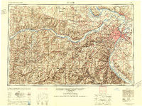
~ St Louis MO topo map, 1:250000 scale, 1 X 2 Degree, Historical, 1949, updated 1949
St Louis, Missouri, USGS topographic map dated 1949.
Includes geographic coordinates (latitude and longitude). This topographic map is suitable for hiking, camping, and exploring, or framing it as a wall map.
Printed on-demand using high resolution imagery, on heavy weight and acid free paper, or alternatively on a variety of synthetic materials.
Topos available on paper, Waterproof, Poly, or Tyvek. Usually shipping rolled, unless combined with other folded maps in one order.
- Product Number: USGS-5575938
- Free digital map download (high-resolution, GeoPDF): St Louis, Missouri (file size: 26 MB)
- Map Size: please refer to the dimensions of the GeoPDF map above
- Weight (paper map): ca. 55 grams
- Map Type: POD USGS Topographic Map
- Map Series: HTMC
- Map Verison: Historical
- Cell ID: 69004
- Scan ID: 325626
- Imprint Year: 1949
- Aerial Photo Year: 1945
- Datum: NAD27
- Map Projection: Transverse Mercator
- Shaded Relief map: Yes
- Map published by United States Army Corps of Engineers
- Map published by United States Army
- Map Language: English
- Scanner Resolution: 600 dpi
- Map Cell Name: Saint Louis
- Grid size: 1 X 2 Degree
- Date on map: 1949
- Map Scale: 1:250000
- Geographical region: Missouri, United States
Neighboring Maps:
All neighboring USGS topo maps are available for sale online at a variety of scales.
Spatial coverage:
Topo map St Louis, Missouri, covers the geographical area associated the following places:
- Forest Homes - Fox Springs - Old Woollam - Maryknoll - Witte Ford (historical) - McCredie - Cahokia - Krakow - Harrison Mills - Southmoor - Matson - Calverton Park - Josephville - Belmont Village - Edmundson - Prairie du Rocher - Woodcrest - Saint Paul - Oakville - Flucom - Woodlands at Bear Creek - Prospect Hill - Earth City - Vinita Park - Weldon - Southhampton - Flint Hill - Shaw - Breckenridge Hills - Yucatan - Natural Bridge Junction - Grantwood Village - Old North Saint Louis - Concord - Calvey (historical) - Dellwood - Silica - Victoria - Calwood - Hollow - The Ville - Deer Plain - Fourche a Renault (historical) - Halifax - Old Monroe - Ranken - Americus - Danby - Union Hill - Gasconade - Wartburg - Arbor Terrace - Jonesburg - Cherokee Park - Millstadt Junction - Peers - Sloan - Belews Creek - Pettys Hill - Lyon - Frankenstein - Hathaway Meadows - Warnock - Schundler - Fredericksburg - Cannon Mines - Kingsway West - Washington - Heilburn (historical) - Aud - Murphy - Pacific - Millstadt - Stolle - Twin Springs - Otto - Rosedale - Upper Alton - North Alton - Machens - Goodfellow Terrace - Hayden - Centaur - Peine Woods - Vandeventer - Cottage Farm - Moro - Glasgow Village - Times Beach (historical) - The Diamonds - Fort Bellefontaine - Pasadena Park - University City - Pitcher - Little Rock Landing - Lakeview - Morschels - Bellefontaine - Tillman - Green Park
- Map Area ID: AREA3938-92-90
- Northwest corner Lat/Long code: USGSNW39-92
- Northeast corner Lat/Long code: USGSNE39-90
- Southwest corner Lat/Long code: USGSSW38-92
- Southeast corner Lat/Long code: USGSSE38-90
- Northern map edge Latitude: 39
- Southern map edge Latitude: 38
- Western map edge Longitude: -92
- Eastern map edge Longitude: -90


