
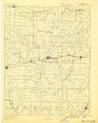
~ Warrensburg MO topo map, 1:125000 scale, 30 X 30 Minute, Historical, 1887
Warrensburg, Missouri, USGS topographic map dated 1887.
Includes geographic coordinates (latitude and longitude). This topographic map is suitable for hiking, camping, and exploring, or framing it as a wall map.
Printed on-demand using high resolution imagery, on heavy weight and acid free paper, or alternatively on a variety of synthetic materials.
Topos available on paper, Waterproof, Poly, or Tyvek. Usually shipping rolled, unless combined with other folded maps in one order.
- Product Number: USGS-5575838
- Free digital map download (high-resolution, GeoPDF): Warrensburg, Missouri (file size: 6 MB)
- Map Size: please refer to the dimensions of the GeoPDF map above
- Weight (paper map): ca. 55 grams
- Map Type: POD USGS Topographic Map
- Map Series: HTMC
- Map Verison: Historical
- Cell ID: 66888
- Scan ID: 325577
- Survey Year: 1885
- Datum: Unstated
- Map Projection: Unstated
- Map published by United States Geological Survey
- Map Language: English
- Scanner Resolution: 600 dpi
- Map Cell Name: Warrensburg
- Grid size: 30 X 30 Minute
- Date on map: 1887
- Map Scale: 1:125000
- Geographical region: Missouri, United States
Neighboring Maps:
All neighboring USGS topo maps are available for sale online at a variety of scales.
Spatial coverage:
Topo map Warrensburg, Missouri, covers the geographical area associated the following places:
- Denton - Bowmansville - Centerview - Knob Noster - Greendoor - Sutherland - Shawnee Mound - Hoffman - Magnolia - Pertle Springs - Burtville - New Castle - Henrietta - Carbon Hill - Odessa - Leeton - Lake Lafayette - Mount Olive - Bowen - Post Oak - Petersburg - Old Chilhowee - Bristle Ridge - Holden - Warrensburg - Owsley - Windsor - Oakland (historical) - Montserrat - Fayetteville - Robbins - Blairstown - Blackwater (historical) - Valley City - Ernestville - Columbus - Chilhowee - Cornelia - Concordia - Norris - Pittsville
- Map Area ID: AREA3938.5-94-93.5
- Northwest corner Lat/Long code: USGSNW39-94
- Northeast corner Lat/Long code: USGSNE39-93.5
- Southwest corner Lat/Long code: USGSSW38.5-94
- Southeast corner Lat/Long code: USGSSE38.5-93.5
- Northern map edge Latitude: 39
- Southern map edge Latitude: 38.5
- Western map edge Longitude: -94
- Eastern map edge Longitude: -93.5


