
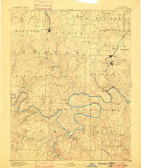
~ Versailles MO topo map, 1:125000 scale, 30 X 30 Minute, Historical, 1893, updated 1900
Versailles, Missouri, USGS topographic map dated 1893.
Includes geographic coordinates (latitude and longitude). This topographic map is suitable for hiking, camping, and exploring, or framing it as a wall map.
Printed on-demand using high resolution imagery, on heavy weight and acid free paper, or alternatively on a variety of synthetic materials.
Topos available on paper, Waterproof, Poly, or Tyvek. Usually shipping rolled, unless combined with other folded maps in one order.
- Product Number: USGS-5575830
- Free digital map download (high-resolution, GeoPDF): Versailles, Missouri (file size: 8 MB)
- Map Size: please refer to the dimensions of the GeoPDF map above
- Weight (paper map): ca. 55 grams
- Map Type: POD USGS Topographic Map
- Map Series: HTMC
- Map Verison: Historical
- Cell ID: 66853
- Scan ID: 325573
- Imprint Year: 1900
- Survey Year: 1886
- Datum: Unstated
- Map Projection: Unstated
- Map published by United States Geological Survey
- Map Language: English
- Scanner Resolution: 600 dpi
- Map Cell Name: Versailles
- Grid size: 30 X 30 Minute
- Date on map: 1893
- Map Scale: 1:125000
- Geographical region: Missouri, United States
Neighboring Maps:
All neighboring USGS topo maps are available for sale online at a variety of scales.
Spatial coverage:
Topo map Versailles, Missouri, covers the geographical area associated the following places:
- Bagnell - Purvis - Aurora Springs - Stover - Eldon - Proctor - West Aurora - Todd (historical) - Laurie - Dodds - Kaiser - Versailles - Linn Creek - Lakeland - Barnett - Bannister Ford - Sunrise Beach - Hurricane Deck - Freedom - Marvin - Lakeside - Cape Galena (historical) - Olean - Laguna Beach - Rocky Mount - Osage Beach - Rocky Mount - Arrowhead Beach - Passover - Old Linn Creek - Gravois Mills - Lakeview - Damsel - Lake Ozark - Barnumton - Camdenton - High Point - Buck Creek - Excelsior - Pleasant Mount - Green Bay Terrace - Toronto - Neongwah - Mount Pleasant - Bannister - Arrowhead - Four Seasons
- Map Area ID: AREA38.538-93-92.5
- Northwest corner Lat/Long code: USGSNW38.5-93
- Northeast corner Lat/Long code: USGSNE38.5-92.5
- Southwest corner Lat/Long code: USGSSW38-93
- Southeast corner Lat/Long code: USGSSE38-92.5
- Northern map edge Latitude: 38.5
- Southern map edge Latitude: 38
- Western map edge Longitude: -93
- Eastern map edge Longitude: -92.5


