
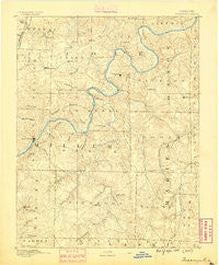
~ Tuscumbia MO topo map, 1:125000 scale, 30 X 30 Minute, Historical, 1888
Tuscumbia, Missouri, USGS topographic map dated 1888.
Includes geographic coordinates (latitude and longitude). This topographic map is suitable for hiking, camping, and exploring, or framing it as a wall map.
Printed on-demand using high resolution imagery, on heavy weight and acid free paper, or alternatively on a variety of synthetic materials.
Topos available on paper, Waterproof, Poly, or Tyvek. Usually shipping rolled, unless combined with other folded maps in one order.
- Product Number: USGS-5575816
- Free digital map download (high-resolution, GeoPDF): Tuscumbia, Missouri (file size: 8 MB)
- Map Size: please refer to the dimensions of the GeoPDF map above
- Weight (paper map): ca. 55 grams
- Map Type: POD USGS Topographic Map
- Map Series: HTMC
- Map Verison: Historical
- Cell ID: 66826
- Scan ID: 325566
- Survey Year: 1886
- Datum: Unstated
- Map Projection: Unstated
- Map published by United States Geological Survey
- Map Language: English
- Scanner Resolution: 600 dpi
- Map Cell Name: Tuscumbia
- Grid size: 30 X 30 Minute
- Date on map: 1888
- Map Scale: 1:125000
- Geographical region: Missouri, United States
Neighboring Maps:
All neighboring USGS topo maps are available for sale online at a variety of scales.
Spatial coverage:
Topo map Tuscumbia, Missouri, covers the geographical area associated the following places:
- Teal (historical) - Shantytown - Millbrook - Sudheimer - Ozark Junction - Meyerstown - Brinktown - Iberia - Ulman - Argyle - Van Cleve - Hickory Hill - Meta - Brumley - Watkins - Etterville - Enon - Koeltztown - Hawkeye - Venus - Samtown - Faith - Brazito - Scrivner - Babbtown - Saint Elizabeth - Wardsville - Henley - Decatur - Saint Thomas - Marys Home - Eugene - Traderight - Lisletown (historical) - Osage Bluff - Hoecker - Castle Rock (historical) - Honey Creek - Spring Garden - Big Bend - Saint Anthony - Keethtown - Capps - Tuscumbia - Payne Ford - Folk - Tavern - Brays - Bass - Atwell - Osage Bend
- Map Area ID: AREA38.538-92.5-92
- Northwest corner Lat/Long code: USGSNW38.5-92.5
- Northeast corner Lat/Long code: USGSNE38.5-92
- Southwest corner Lat/Long code: USGSSW38-92.5
- Southeast corner Lat/Long code: USGSSE38-92
- Northern map edge Latitude: 38.5
- Southern map edge Latitude: 38
- Western map edge Longitude: -92.5
- Eastern map edge Longitude: -92


