
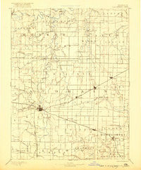
~ Perry MO topo map, 1:125000 scale, 30 X 30 Minute, Historical, 1890, updated 1921
Perry, Missouri, USGS topographic map dated 1890.
Includes geographic coordinates (latitude and longitude). This topographic map is suitable for hiking, camping, and exploring, or framing it as a wall map.
Printed on-demand using high resolution imagery, on heavy weight and acid free paper, or alternatively on a variety of synthetic materials.
Topos available on paper, Waterproof, Poly, or Tyvek. Usually shipping rolled, unless combined with other folded maps in one order.
- Product Number: USGS-5575780
- Free digital map download (high-resolution, GeoPDF): Perry, Missouri (file size: 5 MB)
- Map Size: please refer to the dimensions of the GeoPDF map above
- Weight (paper map): ca. 55 grams
- Map Type: POD USGS Topographic Map
- Map Series: HTMC
- Map Verison: Historical
- Cell ID: 66316
- Scan ID: 325547
- Imprint Year: 1921
- Survey Year: 1887
- Datum: Unstated
- Map Projection: Unstated
- Map published by United States Geological Survey
- Map Language: English
- Scanner Resolution: 600 dpi
- Map Cell Name: Perry
- Grid size: 30 X 30 Minute
- Date on map: 1890
- Map Scale: 1:125000
- Geographical region: Missouri, United States
Neighboring Maps:
All neighboring USGS topo maps are available for sale online at a variety of scales.
Spatial coverage:
Topo map Perry, Missouri, covers the geographical area associated the following places:
- Concord - Martinsburg - Florida - Laddonia - Rush Hill - Auxvasse - Victor - Perry - Ortiz (historical) - Rices Corner - Scotts Corner - Vandiver - Wellsville - Bassinger Corner - Molino - Buzzards Roost - Benton City - Strother - West Hartford - Hollensville - Skinner - Hutchison - Thompson - Farber - Shamrock - Culiver - Worcester - Bryans (historical) - Santa Fe - Champ - Hickory Creek (historical) - Greenlawn - Mexico
- Map Area ID: AREA39.539-92-91.5
- Northwest corner Lat/Long code: USGSNW39.5-92
- Northeast corner Lat/Long code: USGSNE39.5-91.5
- Southwest corner Lat/Long code: USGSSW39-92
- Southeast corner Lat/Long code: USGSSE39-91.5
- Northern map edge Latitude: 39.5
- Southern map edge Latitude: 39
- Western map edge Longitude: -92
- Eastern map edge Longitude: -91.5


