
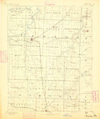
~ Nevada MO topo map, 1:125000 scale, 30 X 30 Minute, Historical, 1894
Nevada, Missouri, USGS topographic map dated 1894.
Includes geographic coordinates (latitude and longitude). This topographic map is suitable for hiking, camping, and exploring, or framing it as a wall map.
Printed on-demand using high resolution imagery, on heavy weight and acid free paper, or alternatively on a variety of synthetic materials.
Topos available on paper, Waterproof, Poly, or Tyvek. Usually shipping rolled, unless combined with other folded maps in one order.
- Product Number: USGS-5575746
- Free digital map download (high-resolution, GeoPDF): Nevada, Missouri (file size: 5 MB)
- Map Size: please refer to the dimensions of the GeoPDF map above
- Weight (paper map): ca. 55 grams
- Map Type: POD USGS Topographic Map
- Map Series: HTMC
- Map Verison: Historical
- Cell ID: 66170
- Scan ID: 325532
- Survey Year: 1884
- Datum: Unstated
- Map Projection: Unstated
- Map published by United States Geological Survey
- Map Language: English
- Scanner Resolution: 600 dpi
- Map Cell Name: Nevada
- Grid size: 30 X 30 Minute
- Date on map: 1894
- Map Scale: 1:125000
- Geographical region: Missouri, United States
Neighboring Maps:
All neighboring USGS topo maps are available for sale online at a variety of scales.
Spatial coverage:
Topo map Nevada, Missouri, covers the geographical area associated the following places:
- Newport - Metz - Donia - Moundville - Irwin - Rousertown - Jerico Springs - Dederick - Iantha - Verdella - Rinehart - Wimmer - Nassau Junction - Milford - Flory (historical) - Bellamy - Nevada - El Dorado Springs - Fair Haven - Montevallo - Sylvania - Greene Springs (historical) - Oak Ridge - Pashaw (historical) - Dean Ford - Handley - Zodiac - Olympia - Osiris - Sheldon - Blaine - Sandstone - Hong - Virgil City - Temple (historical) - Bristow - Walker - Hannon - Bronaugh - Ketterman - Milo - Horton - Harwood - Portia - Ellis
- Map Area ID: AREA3837.5-94.5-94
- Northwest corner Lat/Long code: USGSNW38-94.5
- Northeast corner Lat/Long code: USGSNE38-94
- Southwest corner Lat/Long code: USGSSW37.5-94.5
- Southeast corner Lat/Long code: USGSSE37.5-94
- Northern map edge Latitude: 38
- Southern map edge Latitude: 37.5
- Western map edge Longitude: -94.5
- Eastern map edge Longitude: -94


