
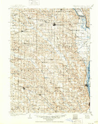
~ Kahoka MO topo map, 1:125000 scale, 30 X 30 Minute, Historical, 1903, updated 1950
Kahoka, Missouri, USGS topographic map dated 1903.
Includes geographic coordinates (latitude and longitude). This topographic map is suitable for hiking, camping, and exploring, or framing it as a wall map.
Printed on-demand using high resolution imagery, on heavy weight and acid free paper, or alternatively on a variety of synthetic materials.
Topos available on paper, Waterproof, Poly, or Tyvek. Usually shipping rolled, unless combined with other folded maps in one order.
- Product Number: USGS-5575670
- Free digital map download (high-resolution, GeoPDF): Kahoka, Missouri (file size: 10 MB)
- Map Size: please refer to the dimensions of the GeoPDF map above
- Weight (paper map): ca. 55 grams
- Map Type: POD USGS Topographic Map
- Map Series: HTMC
- Map Verison: Historical
- Cell ID: 65779
- Scan ID: 325483
- Imprint Year: 1950
- Survey Year: 1900
- Datum: Unstated
- Map Projection: Polyconic
- Map published by United States Geological Survey
- Map Language: English
- Scanner Resolution: 600 dpi
- Map Cell Name: Kahoka
- Grid size: 30 X 30 Minute
- Date on map: 1903
- Map Scale: 1:125000
- Geographical region: Missouri, United States
Neighboring Maps:
All neighboring USGS topo maps are available for sale online at a variety of scales.
Spatial coverage:
Topo map Kahoka, Missouri, covers the geographical area associated the following places:
- Sugar Creek (historical) - Laura - Wyaconda - Durgen - Meyer - New Court Village - Monticello - Revere - Union - Gilead - Vincennes - Ten Mile - Midway - Eldorado - Antioch - Benjamin - Wayland - Neeper - Kahoka - Medill - Fairmont - Etna - Dover - Saint Francisville - Lewistown - Ewing - Deer Ridge - La Belle - Ashton - Forest Springs - Tolona - Weber - Clark City - Derrahs - Salem - Jeddo - Winchester - Colony - Santuzza - Bunker Hill (historical) - Sellers - Williamstown - Saint Patrick - Canton - Luray - Granger - Waterloo - Tully
- Map Area ID: AREA40.540-92-91.5
- Northwest corner Lat/Long code: USGSNW40.5-92
- Northeast corner Lat/Long code: USGSNE40.5-91.5
- Southwest corner Lat/Long code: USGSSW40-92
- Southeast corner Lat/Long code: USGSSE40-91.5
- Northern map edge Latitude: 40.5
- Southern map edge Latitude: 40
- Western map edge Longitude: -92
- Eastern map edge Longitude: -91.5


