
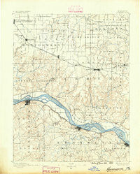
~ Hermann MO topo map, 1:125000 scale, 30 X 30 Minute, Historical, 1890
Hermann, Missouri, USGS topographic map dated 1890.
Includes geographic coordinates (latitude and longitude). This topographic map is suitable for hiking, camping, and exploring, or framing it as a wall map.
Printed on-demand using high resolution imagery, on heavy weight and acid free paper, or alternatively on a variety of synthetic materials.
Topos available on paper, Waterproof, Poly, or Tyvek. Usually shipping rolled, unless combined with other folded maps in one order.
- Product Number: USGS-5575638
- Free digital map download (high-resolution, GeoPDF): Hermann, Missouri (file size: 8 MB)
- Map Size: please refer to the dimensions of the GeoPDF map above
- Weight (paper map): ca. 55 grams
- Map Type: POD USGS Topographic Map
- Map Series: HTMC
- Map Verison: Historical
- Cell ID: 65671
- Scan ID: 325466
- Survey Year: 1887
- Datum: Unstated
- Map Projection: Unstated
- Map published by United States Geological Survey
- Map Language: English
- Scanner Resolution: 600 dpi
- Map Cell Name: Hermann
- Grid size: 30 X 30 Minute
- Date on map: 1890
- Map Scale: 1:125000
- Geographical region: Missouri, United States
Neighboring Maps:
All neighboring USGS topo maps are available for sale online at a variety of scales.
Spatial coverage:
Topo map Hermann, Missouri, covers the geographical area associated the following places:
- Little Berger - Marthasville - Stony Hill - Holstein - Aspenhoff - Hawk Point - Lyon - Lippstadt Community - Bridgeport - Swiss - Big Spring - Macedonia Neighborhood - New Florence - Gore - Bernheimer - Berger - Prairieview (historical) - Morsey (historical) - Hopewell - Case - Abattis (historical) - New Truxton - Baltimore Settlement - Clover Bottom - Jonesburg - Truesdale - Hermann - New Haven - Kohl City - Warrenton - Linns Mills (historical) - Innsbrook - Fourmile Corner - Prices Branch - McKittrick - Campbellton - Kiel - Detmold - Pinckney - Peers - Charrette (historical) - Treloar - Washington - Pendleton - Dundee - Senate Grove (historical) - High Hill - Wright City - Dissen - Concord Hill - Etlah - Kruegerville (historical) - Pin Oak Community
- Map Area ID: AREA3938.5-91.5-91
- Northwest corner Lat/Long code: USGSNW39-91.5
- Northeast corner Lat/Long code: USGSNE39-91
- Southwest corner Lat/Long code: USGSSW38.5-91.5
- Southeast corner Lat/Long code: USGSSE38.5-91
- Northern map edge Latitude: 39
- Southern map edge Latitude: 38.5
- Western map edge Longitude: -91.5
- Eastern map edge Longitude: -91


