
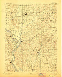
~ Glasgow MO topo map, 1:125000 scale, 30 X 30 Minute, Historical, 1890, updated 1906
Glasgow, Missouri, USGS topographic map dated 1890.
Includes geographic coordinates (latitude and longitude). This topographic map is suitable for hiking, camping, and exploring, or framing it as a wall map.
Printed on-demand using high resolution imagery, on heavy weight and acid free paper, or alternatively on a variety of synthetic materials.
Topos available on paper, Waterproof, Poly, or Tyvek. Usually shipping rolled, unless combined with other folded maps in one order.
- Product Number: USGS-5575614
- Free digital map download (high-resolution, GeoPDF): Glasgow, Missouri (file size: 7 MB)
- Map Size: please refer to the dimensions of the GeoPDF map above
- Weight (paper map): ca. 55 grams
- Map Type: POD USGS Topographic Map
- Map Series: HTMC
- Map Verison: Historical
- Cell ID: 65566
- Scan ID: 325454
- Imprint Year: 1906
- Survey Year: 1887
- Datum: Unstated
- Map Projection: Unstated
- Map published by United States Geological Survey
- Map Language: English
- Scanner Resolution: 600 dpi
- Map Cell Name: Glasgow
- Grid size: 30 X 30 Minute
- Date on map: 1890
- Map Scale: 1:125000
- Geographical region: Missouri, United States
Neighboring Maps:
All neighboring USGS topo maps are available for sale online at a variety of scales.
Spatial coverage:
Topo map Glasgow, Missouri, covers the geographical area associated the following places:
- Salisbury - Steinmetz - Petersburg - New Franklin - Fayette - Boonesboro - Shannondale - Fort Henry - Burton - Thralls Prairie (historical) - Louisville - Aholt - Saline City - Mount Airy - Glasgow - Rockford - Randolph Springs - Yates - Eccles - Hilldale - Wilhite (historical) - Cambridge - Higbee - Namrash (historical) - Keytesville - Forest Green - Arrow Rock - Roanoke - Lisbon - Huntsville - West Glasgow - Clifton Hill - Oil City - Lewis Mill - Bunker Hill - Franklin - Sebree - Cazzell - Armstrong - Landmark (historical) - Punkin Center - Estill - Dalton
- Map Area ID: AREA39.539-93-92.5
- Northwest corner Lat/Long code: USGSNW39.5-93
- Northeast corner Lat/Long code: USGSNE39.5-92.5
- Southwest corner Lat/Long code: USGSSW39-93
- Southeast corner Lat/Long code: USGSSE39-92.5
- Northern map edge Latitude: 39.5
- Southern map edge Latitude: 39
- Western map edge Longitude: -93
- Eastern map edge Longitude: -92.5


