
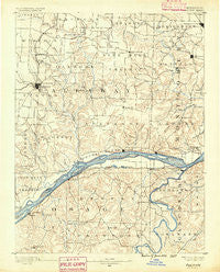
~ Fulton MO topo map, 1:125000 scale, 30 X 30 Minute, Historical, 1890
Fulton, Missouri, USGS topographic map dated 1890.
Includes geographic coordinates (latitude and longitude). This topographic map is suitable for hiking, camping, and exploring, or framing it as a wall map.
Printed on-demand using high resolution imagery, on heavy weight and acid free paper, or alternatively on a variety of synthetic materials.
Topos available on paper, Waterproof, Poly, or Tyvek. Usually shipping rolled, unless combined with other folded maps in one order.
- Product Number: USGS-5575608
- Free digital map download (high-resolution, GeoPDF): Fulton, Missouri (file size: 8 MB)
- Map Size: please refer to the dimensions of the GeoPDF map above
- Weight (paper map): ca. 55 grams
- Map Type: POD USGS Topographic Map
- Map Series: HTMC
- Map Verison: Historical
- Cell ID: 65169
- Scan ID: 325451
- Survey Year: 1887
- Datum: Unstated
- Map Projection: Unstated
- Map published by United States Geological Survey
- Map Language: English
- Scanner Resolution: 600 dpi
- Map Cell Name: Chamois
- Grid size: 30 X 30 Minute
- Date on map: 1890
- Map Scale: 1:125000
- Geographical region: Missouri, United States
Neighboring Maps:
All neighboring USGS topo maps are available for sale online at a variety of scales.
Spatial coverage:
Topo map Fulton, Missouri, covers the geographical area associated the following places:
- Starkenburg - Browns Ford - Steedman - Tebbetts - Rhineland - Loose Creek - Bonnots Mill - Mineola - Crook - Morrison - Krueger Ford - Stolpe - French Village (historical) - Brown Shanty - Bay - Heilburn (historical) - Callaway - Pershing - Yucatan - Portland - Chamois - Calwood - Effie (historical) - McCredie - Luystown - Williamsburg - Kingdom City - Mokane - Aud - Bachelor - Saint Aubert - Isbell (historical) - Fulton - Garrett (historical) - Toledo - Pitcher - Egbert - Americus - Danville - Hams Prairie - Readsville - Gasconade - Frankenstein - Hord (historical) - Feigler Ferry - Reform - Deer - Montgomery City - Cote Sans Dessein (historical) - Liberty - Fredericksburg - Hope - Bluffton - Mint Hill
- Map Area ID: AREA3938.5-92-91.5
- Northwest corner Lat/Long code: USGSNW39-92
- Northeast corner Lat/Long code: USGSNE39-91.5
- Southwest corner Lat/Long code: USGSSW38.5-92
- Southeast corner Lat/Long code: USGSSE38.5-91.5
- Northern map edge Latitude: 39
- Southern map edge Latitude: 38.5
- Western map edge Longitude: -92
- Eastern map edge Longitude: -91.5


