
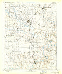
~ Clinton MO topo map, 1:125000 scale, 30 X 30 Minute, Historical, 1894, updated 1932
Clinton, Missouri, USGS topographic map dated 1894.
Includes geographic coordinates (latitude and longitude). This topographic map is suitable for hiking, camping, and exploring, or framing it as a wall map.
Printed on-demand using high resolution imagery, on heavy weight and acid free paper, or alternatively on a variety of synthetic materials.
Topos available on paper, Waterproof, Poly, or Tyvek. Usually shipping rolled, unless combined with other folded maps in one order.
- Product Number: USGS-5575582
- Free digital map download (high-resolution, GeoPDF): Clinton, Missouri (file size: 6 MB)
- Map Size: please refer to the dimensions of the GeoPDF map above
- Weight (paper map): ca. 55 grams
- Map Type: POD USGS Topographic Map
- Map Series: HTMC
- Map Verison: Historical
- Cell ID: 65225
- Scan ID: 325441
- Imprint Year: 1932
- Survey Year: 1885
- Datum: Unstated
- Map Projection: Polyconic
- Map published by United States Geological Survey
- Map Language: English
- Scanner Resolution: 600 dpi
- Map Cell Name: Clinton
- Grid size: 30 X 30 Minute
- Date on map: 1894
- Map Scale: 1:125000
- Geographical region: Missouri, United States
Neighboring Maps:
All neighboring USGS topo maps are available for sale online at a variety of scales.
Spatial coverage:
Topo map Clinton, Missouri, covers the geographical area associated the following places:
- Chalk Level - Montrose - Sparrow - Quarles - Taberville - Lowry City - Monegaw Springs - Corbin (historical) - Mount Zion - Garland - Clinton - Roseland - Delmar - Yolo - Osceola - Lewis - Ninnescah Park - Iuka Springs - Harper - Fox Run - Ohio - Brownington - Gaines - Hortense - Alberta - Hartwell - Browns Ford - Maurine - Calhoun - Iconium - Finey - Leesville - Consville (historical) - Copeland - Huntingdale - Chloe - Deepwater - Livingston - Baker (historical) - Johnson City - Tightwad - Harvey - Coal - La Due
- Map Area ID: AREA38.538-94-93.5
- Northwest corner Lat/Long code: USGSNW38.5-94
- Northeast corner Lat/Long code: USGSNE38.5-93.5
- Southwest corner Lat/Long code: USGSSW38-94
- Southeast corner Lat/Long code: USGSSE38-93.5
- Northern map edge Latitude: 38.5
- Southern map edge Latitude: 38
- Western map edge Longitude: -94
- Eastern map edge Longitude: -93.5


