
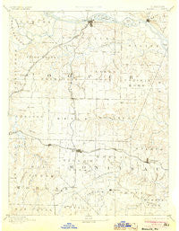
~ Boonville MO topo map, 1:125000 scale, 30 X 30 Minute, Historical, 1888, updated 1904
Boonville, Missouri, USGS topographic map dated 1888.
Includes geographic coordinates (latitude and longitude). This topographic map is suitable for hiking, camping, and exploring, or framing it as a wall map.
Printed on-demand using high resolution imagery, on heavy weight and acid free paper, or alternatively on a variety of synthetic materials.
Topos available on paper, Waterproof, Poly, or Tyvek. Usually shipping rolled, unless combined with other folded maps in one order.
- Product Number: USGS-5575542
- Free digital map download (high-resolution, GeoPDF): Boonville, Missouri (file size: 6 MB)
- Map Size: please refer to the dimensions of the GeoPDF map above
- Weight (paper map): ca. 55 grams
- Map Type: POD USGS Topographic Map
- Map Series: HTMC
- Map Verison: Historical
- Cell ID: 65031
- Scan ID: 325421
- Imprint Year: 1904
- Survey Year: 1886
- Datum: Unstated
- Map Projection: Unstated
- Map Language: English
- Scanner Resolution: 600 dpi
- Map Cell Name: Boonville
- Grid size: 30 X 30 Minute
- Date on map: 1888
- Map Scale: 1:125000
- Geographical region: Missouri, United States
Neighboring Maps:
All neighboring USGS topo maps are available for sale online at a variety of scales.
Spatial coverage:
Topo map Boonville, Missouri, covers the geographical area associated the following places:
- Lamine - Renfro - Speed - Blackwater - Pilot Grove - Pisgah - Clarks Fork - Corticelli - Pleasant Green - Boonville - Cedron - Chouteau Springs - Petersburg (historical) - Florence - Merna - Aikinsville - Billingsville - Lone Elm - California - Overton - Latham - New Lebanon - Syracuse - Windsor Place - Clarksburg - Prairie Home - Corioli (historical) - Hoffman - Pleasant Grove - Fortuna - Wooldridge - Tipton - Kliever - Rocheport - Harriston - Bunceton - Glensted - Bellair - Byberry (historical)
- Map Area ID: AREA3938.5-93-92.5
- Northwest corner Lat/Long code: USGSNW39-93
- Northeast corner Lat/Long code: USGSNE39-92.5
- Southwest corner Lat/Long code: USGSSW38.5-93
- Southeast corner Lat/Long code: USGSSE38.5-92.5
- Northern map edge Latitude: 39
- Southern map edge Latitude: 38.5
- Western map edge Longitude: -93
- Eastern map edge Longitude: -92.5


