
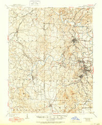
~ Bonne Terre MO topo map, 1:62500 scale, 15 X 15 Minute, Historical, 1905, updated 1950
Bonne Terre, Missouri, USGS topographic map dated 1905.
Includes geographic coordinates (latitude and longitude). This topographic map is suitable for hiking, camping, and exploring, or framing it as a wall map.
Printed on-demand using high resolution imagery, on heavy weight and acid free paper, or alternatively on a variety of synthetic materials.
Topos available on paper, Waterproof, Poly, or Tyvek. Usually shipping rolled, unless combined with other folded maps in one order.
- Product Number: USGS-5574378
- Free digital map download (high-resolution, GeoPDF): Bonne Terre, Missouri (file size: 10 MB)
- Map Size: please refer to the dimensions of the GeoPDF map above
- Weight (paper map): ca. 55 grams
- Map Type: POD USGS Topographic Map
- Map Series: HTMC
- Map Verison: Historical
- Cell ID: 51626
- Scan ID: 324739
- Imprint Year: 1950
- Survey Year: 1903
- Datum: Unstated
- Map Projection: Polyconic
- Map published by United States Geological Survey
- Map Language: English
- Scanner Resolution: 600 dpi
- Map Cell Name: Bonne Terre
- Grid size: 15 X 15 Minute
- Date on map: 1905
- Map Scale: 1:62500
- Geographical region: Missouri, United States
Neighboring Maps:
All neighboring USGS topo maps are available for sale online at a variety of scales.
Spatial coverage:
Topo map Bonne Terre, Missouri, covers the geographical area associated the following places:
- East Flat River - East Bonne Terre - Flat River - Fountain Farm - Davis - Silver Springs - Federal - Cantwell - Cadet - Bonne Terre - Desloge - Park Hills - Bismarck - Elvins - Derby - White (historical) - West Elvins - Settletown - Huntington - Wortham - Terre du Lac - Highley Heights - Saint Francois - Hoffman Junction - Frankclay - Gumbo - The Lead Belt - Hopewell - Leadwood - Fairview Acres - Mineral Point - Loughboro - Adelbert (historical) - Irondale - Mitchell - Daytown - Summit - French Town - Rivermines
- Map Area ID: AREA3837.75-90.75-90.5
- Northwest corner Lat/Long code: USGSNW38-90.75
- Northeast corner Lat/Long code: USGSNE38-90.5
- Southwest corner Lat/Long code: USGSSW37.75-90.75
- Southeast corner Lat/Long code: USGSSE37.75-90.5
- Northern map edge Latitude: 38
- Southern map edge Latitude: 37.75
- Western map edge Longitude: -90.75
- Eastern map edge Longitude: -90.5


