
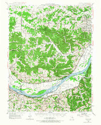
~ Augusta MO topo map, 1:62500 scale, 15 X 15 Minute, Historical, 1948, updated 1967
Augusta, Missouri, USGS topographic map dated 1948.
Includes geographic coordinates (latitude and longitude). This topographic map is suitable for hiking, camping, and exploring, or framing it as a wall map.
Printed on-demand using high resolution imagery, on heavy weight and acid free paper, or alternatively on a variety of synthetic materials.
Topos available on paper, Waterproof, Poly, or Tyvek. Usually shipping rolled, unless combined with other folded maps in one order.
- Product Number: USGS-5574286
- Free digital map download (high-resolution, GeoPDF): Augusta, Missouri (file size: 11 MB)
- Map Size: please refer to the dimensions of the GeoPDF map above
- Weight (paper map): ca. 55 grams
- Map Type: POD USGS Topographic Map
- Map Series: HTMC
- Map Verison: Historical
- Cell ID: 50795
- Scan ID: 324689
- Imprint Year: 1967
- Woodland Tint: Yes
- Aerial Photo Year: 1945
- Field Check Year: 1948
- Datum: NAD27
- Map Projection: Polyconic
- Map published by United States Geological Survey
- Map Language: English
- Scanner Resolution: 600 dpi
- Map Cell Name: Augusta
- Grid size: 15 X 15 Minute
- Date on map: 1948
- Map Scale: 1:62500
- Geographical region: Missouri, United States
Neighboring Maps:
All neighboring USGS topo maps are available for sale online at a variety of scales.
Spatial coverage:
Topo map Augusta, Missouri, covers the geographical area associated the following places:
- Cappeln - Mechanicsville - Defiance - Klondike - Femme Osage - Oetters - New Melle - Augusta - Dartmound (historical) - Howell (historical) - Three Creeks Village - Labadie - South Point (historical) - Boles - Nona - Schluersburg - Saint Albans - Dutzow - Matson
- Map Area ID: AREA38.7538.5-91-90.75
- Northwest corner Lat/Long code: USGSNW38.75-91
- Northeast corner Lat/Long code: USGSNE38.75-90.75
- Southwest corner Lat/Long code: USGSSW38.5-91
- Southeast corner Lat/Long code: USGSSE38.5-90.75
- Northern map edge Latitude: 38.75
- Southern map edge Latitude: 38.5
- Western map edge Longitude: -91
- Eastern map edge Longitude: -90.75


