
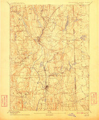
~ Putnam CT topo map, 1:62500 scale, 15 X 15 Minute, Historical, 1893, updated 1910
Putnam, Connecticut, USGS topographic map dated 1893.
Includes geographic coordinates (latitude and longitude). This topographic map is suitable for hiking, camping, and exploring, or framing it as a wall map.
Printed on-demand using high resolution imagery, on heavy weight and acid free paper, or alternatively on a variety of synthetic materials.
Topos available on paper, Waterproof, Poly, or Tyvek. Usually shipping rolled, unless combined with other folded maps in one order.
- Product Number: USGS-5566496
- Free digital map download (high-resolution, GeoPDF): Putnam, Connecticut (file size: 10 MB)
- Map Size: please refer to the dimensions of the GeoPDF map above
- Weight (paper map): ca. 55 grams
- Map Type: POD USGS Topographic Map
- Map Series: HTMC
- Map Verison: Historical
- Cell ID: 61368
- Scan ID: 331150
- Imprint Year: 1910
- Survey Year: 1888
- Datum: Unstated
- Map Projection: Unstated
- Map published by United States Geological Survey
- Map Language: English
- Scanner Resolution: 600 dpi
- Map Cell Name: Putnam
- Grid size: 15 X 15 Minute
- Date on map: 1893
- Map Scale: 1:62500
- Geographical region: Connecticut, United States
Neighboring Maps:
All neighboring USGS topo maps are available for sale online at a variety of scales.
Spatial coverage:
Topo map Putnam, Connecticut, covers the geographical area associated the following places:
- Harrisville - Woodstock - Quaddick - East Putnam - North Grosvenor Dale - Elliotville (historical) - Quebec - Acquidaneck (historical) - Danielson - South Woodstock - Foster - Pomfret Center - Mechanicsville - Putnam - Williams Mill - West Thompson - Thompson - Massomuck (historical) - East Brooklyn - Putnam Heights - Clarkville - Attawaugan - Elmville - East Killingly - Wallum Lake (historical) - West Glocester - East Woodstock - Rogers - North Woodstock - North Foster - Ballouville - South Killingly - Grosvenor Dale - Roseland Park - Pomfret Landing - Dayville - Pomfret - Pineville - Brooklyn - Killingly Center
- Map Area ID: AREA4241.75-72-71.75
- Northwest corner Lat/Long code: USGSNW42-72
- Northeast corner Lat/Long code: USGSNE42-71.75
- Southwest corner Lat/Long code: USGSSW41.75-72
- Southeast corner Lat/Long code: USGSSE41.75-71.75
- Northern map edge Latitude: 42
- Southern map edge Latitude: 41.75
- Western map edge Longitude: -72
- Eastern map edge Longitude: -71.75


