
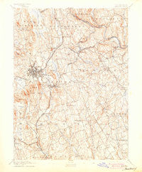
~ Danbury CT topo map, 1:62500 scale, 15 X 15 Minute, Historical, 1892, updated 1904
Danbury, Connecticut, USGS topographic map dated 1892.
Includes geographic coordinates (latitude and longitude). This topographic map is suitable for hiking, camping, and exploring, or framing it as a wall map.
Printed on-demand using high resolution imagery, on heavy weight and acid free paper, or alternatively on a variety of synthetic materials.
Topos available on paper, Waterproof, Poly, or Tyvek. Usually shipping rolled, unless combined with other folded maps in one order.
- Product Number: USGS-5566260
- Free digital map download (high-resolution, GeoPDF): Danbury, Connecticut (file size: 9 MB)
- Map Size: please refer to the dimensions of the GeoPDF map above
- Weight (paper map): ca. 55 grams
- Map Type: POD USGS Topographic Map
- Map Series: HTMC
- Map Verison: Historical
- Cell ID: 53193
- Scan ID: 331003
- Imprint Year: 1904
- Survey Year: 1889
- Datum: Unstated
- Map Projection: Unstated
- Map published by United States Geological Survey
- Map Language: English
- Scanner Resolution: 600 dpi
- Map Cell Name: Danbury
- Grid size: 15 X 15 Minute
- Date on map: 1892
- Map Scale: 1:62500
- Geographical region: Connecticut, United States
Neighboring Maps:
All neighboring USGS topo maps are available for sale online at a variety of scales.
Spatial coverage:
Topo map Danbury, Connecticut, covers the geographical area associated the following places:
- Wildmans Landing - Botsford - Candlewood Knolls - Ta'agan Point - Sanfordtown - Pootatuck Park - Sandy Hook - New Fairfield - Berkshire Estates - Lattins Landing - Fox Hill - Hawleyville - Hawthorne Terrace - Palestine - West Redding - Selleck Four Corners (historical) - Rocky Glen - Aqua Vista - Redding - Beckettville - Miry Brook - Lonetown - Morgan Fair Corners - Branchville - Redding Ridge - Easton - Boston - Casagmo - Bethel - Hayestown - Germantown - Upper Stepney - South Britain - Danbury - Hattertown - Hopewell - Candlewood Lake Club - Russian Village - Shady Rest - Candlewood Shores - Obtuse Hill - Knollcrest - Topstone - Candlewood Orchards - Oakdale Manor - Candlewood Pines - Huntingtown - Ridgefield - Brookfield - Margerie Manor - Five Points - Hollywyle Park - Beaverbrook - Wataba Lake - Snug Harbor - Cedar Heights - Brookfield Center - Stepney - Rock Raymond - Dodgingtown - Georgetown - Pleasant Acres - Newtown - Berkshire
- Map Area ID: AREA41.541.25-73.5-73.25
- Northwest corner Lat/Long code: USGSNW41.5-73.5
- Northeast corner Lat/Long code: USGSNE41.5-73.25
- Southwest corner Lat/Long code: USGSSW41.25-73.5
- Southeast corner Lat/Long code: USGSSE41.25-73.25
- Northern map edge Latitude: 41.5
- Southern map edge Latitude: 41.25
- Western map edge Longitude: -73.5
- Eastern map edge Longitude: -73.25


