
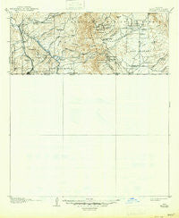
~ Nogales AZ topo map, 1:125000 scale, 30 X 30 Minute, Historical, 1905, updated 1947
Nogales, Arizona, USGS topographic map dated 1905.
Includes geographic coordinates (latitude and longitude). This topographic map is suitable for hiking, camping, and exploring, or framing it as a wall map.
Printed on-demand using high resolution imagery, on heavy weight and acid free paper, or alternatively on a variety of synthetic materials.
Topos available on paper, Waterproof, Poly, or Tyvek. Usually shipping rolled, unless combined with other folded maps in one order.
- Product Number: USGS-5549398
- Free digital map download (high-resolution, GeoPDF): Nogales, Arizona (file size: 5 MB)
- Map Size: please refer to the dimensions of the GeoPDF map above
- Weight (paper map): ca. 55 grams
- Map Type: POD USGS Topographic Map
- Map Series: HTMC
- Map Verison: Historical
- Cell ID: 66204
- Scan ID: 314849
- Imprint Year: 1947
- Survey Year: 1904
- Datum: Unstated
- Map Projection: Polyconic
- Map published by United States Geological Survey
- Map Language: English
- Scanner Resolution: 600 dpi
- Map Cell Name: Nogales
- Grid size: 30 X 30 Minute
- Date on map: 1905
- Map Scale: 1:125000
- Geographical region: Arizona, United States
Neighboring Maps:
All neighboring USGS topo maps are available for sale online at a variety of scales.
Spatial coverage:
Topo map Nogales, Arizona, covers the geographical area associated the following places:
- Calabasas - Beyerville - Nogales - Lochiel - Washington Camp - Kino Springs - Mi Casa Mobile Home Park - Harshaw - Trench Camp - Rio Rico - Duquesne
- Map Area ID: AREA31.531-111-110.5
- Northwest corner Lat/Long code: USGSNW31.5-111
- Northeast corner Lat/Long code: USGSNE31.5-110.5
- Southwest corner Lat/Long code: USGSSW31-111
- Southeast corner Lat/Long code: USGSSE31-110.5
- Northern map edge Latitude: 31.5
- Southern map edge Latitude: 31
- Western map edge Longitude: -111
- Eastern map edge Longitude: -110.5


