
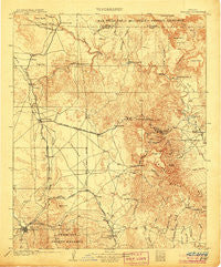
~ Jerome AZ topo map, 1:125000 scale, 30 X 30 Minute, Historical, 1905
Jerome, Arizona, USGS topographic map dated 1905.
Includes geographic coordinates (latitude and longitude). This topographic map is suitable for hiking, camping, and exploring, or framing it as a wall map.
Printed on-demand using high resolution imagery, on heavy weight and acid free paper, or alternatively on a variety of synthetic materials.
Topos available on paper, Waterproof, Poly, or Tyvek. Usually shipping rolled, unless combined with other folded maps in one order.
- Product Number: USGS-5549374
- Free digital map download (high-resolution, GeoPDF): Jerome, Arizona (file size: 9 MB)
- Map Size: please refer to the dimensions of the GeoPDF map above
- Weight (paper map): ca. 55 grams
- Map Type: POD USGS Topographic Map
- Map Series: HTMC
- Map Verison: Historical
- Cell ID: 65761
- Scan ID: 315369
- Survey Year: 1903
- Datum: Unstated
- Map Projection: Unstated
- Map published by United States Geological Survey
- Map Language: English
- Scanner Resolution: 600 dpi
- Map Cell Name: Jerome
- Grid size: 30 X 30 Minute
- Date on map: 1905
- Map Scale: 1:125000
- Geographical region: Arizona, United States
Neighboring Maps:
All neighboring USGS topo maps are available for sale online at a variety of scales.
Spatial coverage:
Topo map Jerome, Arizona, covers the geographical area associated the following places:
- Centerville - Verde Village - Chino Valley - Granite Dells - Cottonwood - Vista Del Sol Mobile Home Park - Jerome - Drake - Dewey-Humboldt - Yavapai Hills - Entro - Mack - Perkinsville - Blue Hills Farms - Cherry - Lampliter Village Mobile Home Park - Del Rio - Shady Acres Mobile Park - Humboldt - Shadow Mountain Mobile Home Park - Oak Knoll Village - Casa Loma Mobile Home Park - Fort Whipple - Country West Mobile Home Park - Sycamore - Bear - Pine Lawn Ranch Mobile Home Park - Granite Siding - Cottonwood Heights Mobile Home Park - Dewey - Miller Valley - Prescott Gardens Mobile Home Park - White Cloud Mobile Home Park - Forbing Park - Heritage Mobile Home Park - Tutt - Clarkdale - Prescott - Prescott Valley - Castle Canyon Mesa - Canyon Retreat Mobile Home Park - Tapco - Hecla - Juniper Heights - Prescott Pines Mobile Home Resort - Whipple - Paulden - Roadrunner Mobile Home Park - Pine Haven Mobile Home Park - Diamond Valley - Beverly Gardens Trailer Park - P and E Junction - Iron Springs Manor Mobile Home Park - Abra - Clemenceau
- Map Area ID: AREA3534.5-112.5-112
- Northwest corner Lat/Long code: USGSNW35-112.5
- Northeast corner Lat/Long code: USGSNE35-112
- Southwest corner Lat/Long code: USGSSW34.5-112.5
- Southeast corner Lat/Long code: USGSSE34.5-112
- Northern map edge Latitude: 35
- Southern map edge Latitude: 34.5
- Western map edge Longitude: -112.5
- Eastern map edge Longitude: -112


