
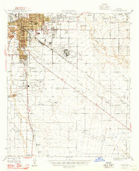
~ Tucson AZ topo map, 1:62500 scale, 15 X 15 Minute, Historical, 1948
Tucson, Arizona, USGS topographic map dated 1948.
Includes geographic coordinates (latitude and longitude). This topographic map is suitable for hiking, camping, and exploring, or framing it as a wall map.
Printed on-demand using high resolution imagery, on heavy weight and acid free paper, or alternatively on a variety of synthetic materials.
Topos available on paper, Waterproof, Poly, or Tyvek. Usually shipping rolled, unless combined with other folded maps in one order.
- Product Number: USGS-5548886
- Free digital map download (high-resolution, GeoPDF): Tucson, Arizona (file size: 6 MB)
- Map Size: please refer to the dimensions of the GeoPDF map above
- Weight (paper map): ca. 55 grams
- Map Type: POD USGS Topographic Map
- Map Series: HTMC
- Map Verison: Historical
- Cell ID: 63729
- Scan ID: 315130
- Datum: NAD27
- Map Projection: Polyconic
- Map published by United States Geological Survey
- Map Language: English
- Scanner Resolution: 600 dpi
- Map Cell Name: Tucson
- Grid size: 15 X 15 Minute
- Date on map: 1948
- Map Scale: 1:62500
- Geographical region: Arizona, United States
Neighboring Maps:
All neighboring USGS topo maps are available for sale online at a variety of scales.
Spatial coverage:
Topo map Tucson, Arizona, covers the geographical area associated the following places:
- Pantano Vista Mobile Home Park - South Tucson - Vandenberg Village - Las Palmes Mobile Home Park - El Rio - Desert Pueblo Mobile Home Park - Polvo - Pueblo Gardens - Covered Wagon Mobile Home Park - Polo Village - Via Verde West Mobile Home Park - Esmond - Triple K Mobile Home Park - Desert Breeze Mobile Home Park - Arizona Trailer Court - Town and Country Mobile Home Park - Tucson Meadows Mobile Home Park - Tucson - Southgate Mobile Home Park - Mobile Air Park - Village Mobile Home Park - Far Horizons East Mobile Home Park - Buffalo Mobile Home Park - Apache Village Trailer Park - Rincon Mobile Home Village - Emery Park - Silverlake Estates Mobile Home Park - Plaza Del Sol Mobile Home Resort - Pima Ramada Mobile Home Park - Desert Vista Mobile Home Park - Arizona Prarie Mobile Home Park - Harrison Hills Mobile Home Park - Palomino Mobile Home Community - El Camino Mobile Park - Brentwood Mobile Home Park - Mission View Club Estates Mobile Home Park - Wilmot - Littletown - Rolling Hills Country Club Estates - Casa Dulce Mobile Home Park - Desert Willows Mobile Home Park Estates - Pascua Yaqui Indian Village - Far Horizons Trailer Village - Craycroft - Rankin - Crossroads Mobile Home Park - Mountain Vista Mobile Home Park - Cadillac Mobile Home Park - Kingston Knolls Terrace - Redwood Mobile Home Park - Golden Dawn Mobile Home Park - Verde Plaza Mobile Home Park - Colonial Mobile Homes Park - Mesa Ridge Mobile Home Park - Civano - Ranchwood Mobile Home Park - Summit - Cottonwood Manor Mobile Home Park - Los Ranchitos Mobile Home Park - Parklane Mobile Estates - Desert Classic Mobile Home Park - Far Horizons Mobile Home Park - Country Club Mobile Home Park
- Map Area ID: AREA32.2532-111-110.75
- Northwest corner Lat/Long code: USGSNW32.25-111
- Northeast corner Lat/Long code: USGSNE32.25-110.75
- Southwest corner Lat/Long code: USGSSW32-111
- Southeast corner Lat/Long code: USGSSE32-110.75
- Northern map edge Latitude: 32.25
- Southern map edge Latitude: 32
- Western map edge Longitude: -111
- Eastern map edge Longitude: -110.75


