
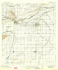
~ Mesa AZ topo map, 1:62500 scale, 15 X 15 Minute, Historical, 1915, updated 1938
Mesa, Arizona, USGS topographic map dated 1915.
Includes geographic coordinates (latitude and longitude). This topographic map is suitable for hiking, camping, and exploring, or framing it as a wall map.
Printed on-demand using high resolution imagery, on heavy weight and acid free paper, or alternatively on a variety of synthetic materials.
Topos available on paper, Waterproof, Poly, or Tyvek. Usually shipping rolled, unless combined with other folded maps in one order.
- Product Number: USGS-5548276
- Free digital map download (high-resolution, GeoPDF): Mesa, Arizona (file size: 5 MB)
- Map Size: please refer to the dimensions of the GeoPDF map above
- Weight (paper map): ca. 55 grams
- Map Type: POD USGS Topographic Map
- Map Series: HTMC
- Map Verison: Historical
- Cell ID: 57554
- Scan ID: 314798
- Imprint Year: 1938
- Survey Year: 1913
- Datum: Unstated
- Map Projection: Polyconic
- Map published by United States Geological Survey
- Map Language: English
- Scanner Resolution: 600 dpi
- Map Cell Name: Mesa
- Grid size: 15 X 15 Minute
- Date on map: 1915
- Map Scale: 1:62500
- Geographical region: Arizona, United States
Neighboring Maps:
All neighboring USGS topo maps are available for sale online at a variety of scales.
Spatial coverage:
Topo map Mesa, Arizona, covers the geographical area associated the following places:
- Shady Ranch Trailer Lodge - Holiday Village Mobile Home Park - Wishing Well Trailer Park - Silvergate Trails - Parkside - Tempe Royal Palms - Brentwood West - MonDak Mobile Home Park - Paradise Palms Trailer Resorts - Suntrails - Chaparral Mobile Village - Dusk File - Sunrise Vista Mobile Home Park - Mesa Village Mobile Home Park - Kay-Bee Mobile Villa - Marlborough Mesa - Los Tesoros - Falfa - Imperial Mobile Home Park - Chandler Gardens Mobile Home Park - Woodland Heights - Evergreen Villa Mobile Home Park - Summer Place Trails - Suncrest Villas Chandler - Los Maderas - West Chandler - Country Club Village Mobile Home Park - Burgundy Hill - Knoell East - Casa Linda - Tremaine - Rancho Tempe Family and Adult Mobile Home Park - Village of Gila Springs - Homestead - Lariat Tra-Tel Trailer Court - McClintock Manor - A and F Trailer Court - Mesa Gardens Mobile Home Park - Brentwood West Mobile Home Park - Lehi - Starlite Trailer Park - Continental Tempe - Prado del Sol - Tovrea - Greenhaven Mobile Park - Silvergate II - Estates La Colina - Tempe - The Lakes - Dobson Ranch - Amberwood II - Quail Place - Mesa Grande Trailer Ranch - Hightown - Hyde Park Lodge - Shadow Mountain Village Scottsdale - Garden Spot Mobile Home Park - Cloverleaf - Minnesota Court - Woodglen - Windsor Mobile Home Park - Suntree - Roadrunner Lake Resort Mobile Home Park - El Mar Trailer Court - Crestview - Rancho Rio Vista Mobile Home Park - Womack East - Palo Verde Mobile Manor - Sonora Town - Keats Crossing - La Casita Mobile Park - Mission Valley - Orangetree - Cypress Estates - Sunview - Canyon Run - Glenview Estates - The Meadows Mobile Home Park - Cibola Mobile Home Park - Chandler Meadows Mobile Home Park - Valley Mobile Homes Estate - Knoell Mesa - Warner Park - Holiday Village Mobile Home Park - Pony Acres Mobile Home Park - Shadow Mountain Village - The Haciendas - Eastway Mobile Home Park - Alta Mira - Kingsgate - Guadalupe - Ambassador Downs Mobile Home Park - Green Tree Mobile Home Park - Paradise View Mobile Home Park - Southern Palms Trailer Park - The Landings - Apache West Mobile Village - Admiral Trailer Park - Big Palm Trailer Park - Redwood Gardens Mobile Home Park
- Map Area ID: AREA33.533.25-112-111.75
- Northwest corner Lat/Long code: USGSNW33.5-112
- Northeast corner Lat/Long code: USGSNE33.5-111.75
- Southwest corner Lat/Long code: USGSSW33.25-112
- Southeast corner Lat/Long code: USGSSE33.25-111.75
- Northern map edge Latitude: 33.5
- Southern map edge Latitude: 33.25
- Western map edge Longitude: -112
- Eastern map edge Longitude: -111.75


