
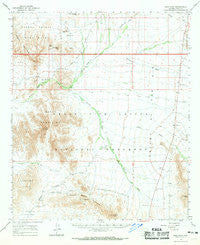
~ Kino Peak AZ topo map, 1:62500 scale, 15 X 15 Minute, Historical, 1963, updated 1969
Kino Peak, Arizona, USGS topographic map dated 1963.
Includes geographic coordinates (latitude and longitude). This topographic map is suitable for hiking, camping, and exploring, or framing it as a wall map.
Printed on-demand using high resolution imagery, on heavy weight and acid free paper, or alternatively on a variety of synthetic materials.
Topos available on paper, Waterproof, Poly, or Tyvek. Usually shipping rolled, unless combined with other folded maps in one order.
- Product Number: USGS-5548138
- Free digital map download (high-resolution, GeoPDF): Kino Peak, Arizona (file size: 6 MB)
- Map Size: please refer to the dimensions of the GeoPDF map above
- Weight (paper map): ca. 55 grams
- Map Type: POD USGS Topographic Map
- Map Series: HTMC
- Map Verison: Historical
- Cell ID: 56218
- Scan ID: 314718
- Imprint Year: 1969
- Woodland Tint: Yes
- Aerial Photo Year: 1961
- Field Check Year: 1963
- Datum: NAD27
- Map Projection: Polyconic
- Map published by United States Geological Survey
- Map Language: English
- Scanner Resolution: 600 dpi
- Map Cell Name: Kino Peak
- Grid size: 15 X 15 Minute
- Date on map: 1963
- Map Scale: 1:62500
- Geographical region: Arizona, United States
Neighboring Maps:
All neighboring USGS topo maps are available for sale online at a variety of scales.
Spatial coverage:
Topo map Kino Peak, Arizona, covers the geographical area associated the following places:
- Bates Mountains - Kino Peak - Bonita Well - Tillotson Peak - Lime Hill - Cuerda de Lena - Bates Well - Puerto Blanco Drive - Bluebird Mine - Growler Canyon - Daniells Well - Growler Pass - Pinkley Peak - Dripping Springs - Ajo Division - Cherioni Wash - Acuna Well - Cipriano Hills - Alamo Wash - Kuakatch Wash - Armenta Well - Puerto Blanco Mountains - Copper Mountain Mine - Bandeja Well - Puerto Blanco Pass - Scarface Mountain - Organ Pipe Cactus National Monument - Organ Pipe Cactus Wilderness
- Map Area ID: AREA32.2532-113-112.75
- Northwest corner Lat/Long code: USGSNW32.25-113
- Northeast corner Lat/Long code: USGSNE32.25-112.75
- Southwest corner Lat/Long code: USGSSW32-113
- Southeast corner Lat/Long code: USGSSE32-112.75
- Northern map edge Latitude: 32.25
- Southern map edge Latitude: 32
- Western map edge Longitude: -113
- Eastern map edge Longitude: -112.75


