
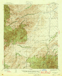
~ Jackson Mtn AZ topo map, 1:62500 scale, 15 X 15 Minute, Historical, 1946
Jackson Mtn , Arizona, USGS topographic map dated 1946.
Includes geographic coordinates (latitude and longitude). This topographic map is suitable for hiking, camping, and exploring, or framing it as a wall map.
Printed on-demand using high resolution imagery, on heavy weight and acid free paper, or alternatively on a variety of synthetic materials.
Topos available on paper, Waterproof, Poly, or Tyvek. Usually shipping rolled, unless combined with other folded maps in one order.
- Product Number: USGS-5548098
- Free digital map download (high-resolution, GeoPDF): Jackson Mtn , Arizona (file size: 10 MB)
- Map Size: please refer to the dimensions of the GeoPDF map above
- Weight (paper map): ca. 55 grams
- Map Type: POD USGS Topographic Map
- Map Series: HTMC
- Map Verison: Historical
- Cell ID: 55830
- Scan ID: 314699
- Woodland Tint: Yes
- Datum: NAD27
- Map Projection: Polyconic
- Map published by United States Geological Survey
- Map Language: English
- Scanner Resolution: 600 dpi
- Map Cell Name: Jackson Mountain
- Grid size: 15 X 15 Minute
- Date on map: 1946
- Map Scale: 1:62500
- Geographical region: Arizona, United States
Neighboring Maps:
All neighboring USGS topo maps are available for sale online at a variety of scales.
Spatial coverage:
Topo map Jackson Mtn , Arizona, covers the geographical area associated the following places:
- Juan Hill - Fisher Basin - Blue Ridge - Lower Two Troughs Tank - Cottonwood Mountain - Dark Canyon Spring - Brushy Tank - Ladrone Tank - Two Troughs Canyon - Pinnacle Ridge - Mud Spring Mesa - Black Rock Trail Two Hundred Ninety Two - Eagle Pass - Mesquite Well - New Tank - Corner Tank - Fisher Basin Spring - Preacher Spring - Kennedy Falls Spring - Limestone Canyon - Cottonwood Tank - Buford Hill - Black Rock Dam Tank - Gardner Canyon Sixty seven Trail - Sycamore Spring - Santa Teresa Wilderness - Buford Tank - South Fork Goodwin Canyon - Lone Pine Spring - Goat Water Tank - Beauchamp Canyon - Kane Spring - VJ Tank - Jackson Mountain - T Hinton Ranch - Y L Ranch - Telegraph Wash - Santa Teresa Mountains - North Santa Teresa Wilderness - Underwood Wash - Holladay Ranch - Water Canyon - Black Rock - Fourmile Spring - Tripp Canyon - Pipeline Tank - Deer Tank - Roundup Grounds Canyon - Black Rock Canyon - Sycamore Spring - Cedar Springs Butte - Holdout Tank - North Two Troughs Tank - Cottonwood Canyon - Grama Tank - Cold Spring Canyon - Holdout Creek - Middle Point Tank - Little Righthand Canyon - Preacher Canyon - Holdout Canyon - Mud Spring - Calf Spring - Corral Well - White Spring - Oak Butte - Register Tank - Bellows Canyon - Sawmill Canyon - Norton Spring - Sycamore Canyon - Devil Tank - Cluff Peak - Indian Spring - Hackberry Draw - Cedar Point Tank - Dry Lake Stock Tank - Fisher Canyon - Lee Tank - Fisher Basin Trail Sixty four - Fourmile Canyon - Upper Falls Spring - Cedar Springs - Section Twenty-eight Tank - Hinton Ranch - Devils Hole - The Box - Crazy Horse Spring - Underwood Canyon - Cobre Grande Peak - Spar Mine - Dark Canyon - Holdup Canyon - Eureka Tank - Holdout Mesa - Sawmill Spring - Wide Mouth Tank - Crazy Horse Wash - Oak Creek - Lower Holdout
- Map Area ID: AREA3332.75-110.25-110
- Northwest corner Lat/Long code: USGSNW33-110.25
- Northeast corner Lat/Long code: USGSNE33-110
- Southwest corner Lat/Long code: USGSSW32.75-110.25
- Southeast corner Lat/Long code: USGSSE32.75-110
- Northern map edge Latitude: 33
- Southern map edge Latitude: 32.75
- Western map edge Longitude: -110.25
- Eastern map edge Longitude: -110


