
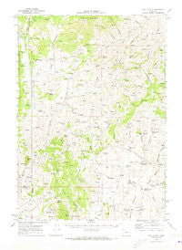
~ Castle Rock OR topo map, 1:62500 scale, 15 X 15 Minute, Historical, 1970, updated 1973
Castle Rock, Oregon, USGS topographic map dated 1970.
Includes geographic coordinates (latitude and longitude). This topographic map is suitable for hiking, camping, and exploring, or framing it as a wall map.
Printed on-demand using high resolution imagery, on heavy weight and acid free paper, or alternatively on a variety of synthetic materials.
Topos available on paper, Waterproof, Poly, or Tyvek. Usually shipping rolled, unless combined with other folded maps in one order.
- Product Number: USGS-5544374
- Free digital map download (high-resolution, GeoPDF): Castle Rock, Oregon (file size: 8 MB)
- Map Size: please refer to the dimensions of the GeoPDF map above
- Weight (paper map): ca. 55 grams
- Map Type: POD USGS Topographic Map
- Map Series: HTMC
- Map Verison: Historical
- Cell ID: 52263
- Scan ID: 282317
- Imprint Year: 1973
- Woodland Tint: Yes
- Aerial Photo Year: 1969
- Field Check Year: 1970
- Datum: NAD27
- Map Projection: Polyconic
- Map published by United States Geological Survey
- Map Language: English
- Scanner Resolution: 600 dpi
- Map Cell Name: Castle Rock
- Grid size: 15 X 15 Minute
- Date on map: 1970
- Map Scale: 1:62500
- Geographical region: Oregon, United States
Neighboring Maps:
All neighboring USGS topo maps are available for sale online at a variety of scales.
Spatial coverage:
Topo map Castle Rock, Oregon, covers the geographical area associated the following places:
- Steamboat Rock - Puckett Creek - Station Creek - Baker City Springs - Godding Creek - Hunter Spring - Horse Flat Reservoir - Castle Spring - Big Flat - Hunter Mountain - Black Stump Canyon - Sheep Dip Canyon - Lost Creek - The Holdout Cow Camp - Lockhart Airport - Mouse Lake - Steamboat Creek - Juniper Spring - Ring Butte - Cold Spring - Kitten Canyon - Castle View Spring - Black Butte - Log Spring - McArthur Creek - Horse Flat - North Bully Creek - Beaver Dam Creek - Mona Creek - Sheep Rock Springs - Deadwood Creek - Little Cottonwood Creek - Bridge Creek - Pinto Springs - Willow Basin - McArthur Spring - Hunter Mountain Spring - Black Pasture - Táx̣špa Butte - Hunter Campground - Little Lost Creek - De Bord - Castle Rock - Buckskin Spring - Kitten Canyon Reservoir - South Clover Creek - Dutch John Section - Earp Spring - Byars Spring - Steamboat Spring - Sheep Rock - Willow Basin Creek - South Bully Creek - Mailbox Canyon - Dutch John Creek - Mailbox Canyon Reservoir - Beaver Dam Flat - Hunter Creek - Timber Gulch - Wilson Spring - Anderson Creek - Whisky Gulch Springs - Castle Rock Spring - Willow Basin Reservoir - Ironside Mountain - Clevenger Butte - Rail Canyon - Big Flat Reservoir - Willow Basin Spring - Goodwin Tomb - Kitten Canyon Spring - Castle Rock Fire Station - West Fork Bendire Creek - Mouse Spring - Cannon Gulch - Lockhart Crossing - Dutch John Cabin - Hunter Ranch - Baker City Canyon - Campspot Spring - Irish Spring - Whisky Gulch - Schoolmarm Spring - Baker City Draw - Lost Creek Spring - Hunter Ditch
- Map Area ID: AREA44.2544-118.25-118
- Northwest corner Lat/Long code: USGSNW44.25-118.25
- Northeast corner Lat/Long code: USGSNE44.25-118
- Southwest corner Lat/Long code: USGSSW44-118.25
- Southeast corner Lat/Long code: USGSSE44-118
- Northern map edge Latitude: 44.25
- Southern map edge Latitude: 44
- Western map edge Longitude: -118.25
- Eastern map edge Longitude: -118


