
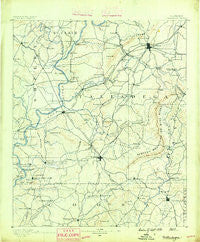
~ Talladega AL topo map, 1:125000 scale, 30 X 30 Minute, Historical, 1890
Talladega, Alabama, USGS topographic map dated 1890.
Includes geographic coordinates (latitude and longitude). This topographic map is suitable for hiking, camping, and exploring, or framing it as a wall map.
Printed on-demand using high resolution imagery, on heavy weight and acid free paper, or alternatively on a variety of synthetic materials.
Topos available on paper, Waterproof, Poly, or Tyvek. Usually shipping rolled, unless combined with other folded maps in one order.
- Product Number: USGS-5542827
- Free digital map download (high-resolution, GeoPDF): Talladega, Alabama (file size: 7 MB)
- Map Size: please refer to the dimensions of the GeoPDF map above
- Weight (paper map): ca. 55 grams
- Map Type: POD USGS Topographic Map
- Map Series: HTMC
- Map Verison: Historical
- Cell ID: 66751
- Scan ID: 305887
- Survey Year: 1888
- Datum: Unstated
- Map Projection: Unstated
- Map published by United States Geological Survey
- Map Language: English
- Scanner Resolution: 600 dpi
- Map Cell Name: Talladega
- Grid size: 30 X 30 Minute
- Date on map: 1890
- Map Scale: 1:125000
- Geographical region: Alabama, United States
Neighboring Maps:
All neighboring USGS topo maps are available for sale online at a variety of scales.
Spatial coverage:
Topo map Talladega, Alabama, covers the geographical area associated the following places:
- Chambers Springs - Kings Chapel - Papertown - Hatchet - Willingham Estates - Fountainrun (historical) - Taylors Mill - Weogufka - Harpersville - Saint Ives - Jonesview - Unity - Midway - Fair Park - Abihka (historical) - Tucktown - Carleton Point - New London - Cedar Cove Estates - Shocco Springs - Hanover - Five Points - Talladega Springs - Gantts Quarry - Kahatchee - Logan Martin Pines - Alpine Bay - Bethel - Gallups Crossroads - Alpine - Winterboro - Kowakas Mobile Home Park - Zubers - Kymulga - Creswell - Clear Creek Estates - Calcis - Barclay - Ledbetters - Odena - Emauhee - Thomas Hill - Grasmere - Wilsonville - McCannsville - Arkwright - Valentine - Jonesville - Hatchet Creek - Chico - Parkdale - Sulphur Spring - Coosa Court - Mardisville - Belle Vista - Marble Valley - Oldfield - Gage - Fayetteville - Plantersville - Sunrise - Abbot Springs - Childersburg - Chancellor Crossroads - Stockdale - Cloverdale - Forest Hills - Howells Cove - Berneys - Coosa Pines - Bemiston - Saint Clair Shores - Sterrett - Brecon - Strickland Crossroads - Grove Park - Roselle - Mount Olive - Comerdale - Ledbetter - Reynolds Mill - Reubenville - Fishtrap - Mount Olive Circle - Skeggs Crossroads - Allison Mills - Coleta - Gantts Junction - Vincent - Paradise Point Estates - Deans - Warm Springs - Thornhill - Goodwater - Hollins - Liberty Hill - East Mill - Country Club Estates - Shady Grove - Blue Springs
- Map Area ID: AREA33.533-86.5-86
- Northwest corner Lat/Long code: USGSNW33.5-86.5
- Northeast corner Lat/Long code: USGSNE33.5-86
- Southwest corner Lat/Long code: USGSSW33-86.5
- Southeast corner Lat/Long code: USGSSE33-86
- Northern map edge Latitude: 33.5
- Southern map edge Latitude: 33
- Western map edge Longitude: -86.5
- Eastern map edge Longitude: -86


