
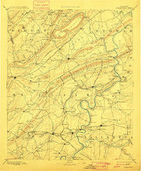
~ Springville AL topo map, 1:125000 scale, 30 X 30 Minute, Historical, 1892, updated 1911
Springville, Alabama, USGS topographic map dated 1892.
Includes geographic coordinates (latitude and longitude). This topographic map is suitable for hiking, camping, and exploring, or framing it as a wall map.
Printed on-demand using high resolution imagery, on heavy weight and acid free paper, or alternatively on a variety of synthetic materials.
Topos available on paper, Waterproof, Poly, or Tyvek. Usually shipping rolled, unless combined with other folded maps in one order.
- Product Number: USGS-5542803
- Free digital map download (high-resolution, GeoPDF): Springville, Alabama (file size: 7 MB)
- Map Size: please refer to the dimensions of the GeoPDF map above
- Weight (paper map): ca. 55 grams
- Map Type: POD USGS Topographic Map
- Map Series: HTMC
- Map Verison: Historical
- Cell ID: 66679
- Scan ID: 305875
- Imprint Year: 1911
- Survey Year: 1887
- Datum: Unstated
- Map Projection: Unstated
- Map published by United States Geological Survey
- Map Language: English
- Scanner Resolution: 600 dpi
- Map Cell Name: Springville
- Grid size: 30 X 30 Minute
- Date on map: 1892
- Map Scale: 1:125000
- Geographical region: Alabama, United States
Neighboring Maps:
All neighboring USGS topo maps are available for sale online at a variety of scales.
Spatial coverage:
Topo map Springville, Alabama, covers the geographical area associated the following places:
- Wendy Wood - Markton - Yatesville - Avondale Village - Cooks Springs - Old Eastaboga - Windsong Island - Shiloh - Crockertown - Ilamo - Lakeview - Embry Crossroads - Wolf Creek - Old Harmony - Enchanted Hills - Cropwell - Harmon - Etowahton (historical) - Eureka Shores - Ashville - Boiling Springs - Twin Lake Estates - Cape Choccolocco - Morgans Crossroads - Chulavista - Bethlehem - Taits Gap - Bruner (historical) - Macon - Acmar - Cochran Springs (historical) - Rock Inn Estates - Saint Clair Springs - Nix (historical) - Lawley - Chandler Mountain - Womack (historical) - Pleasant Grove - Davis Acres - Camelot Plateau - Walkerton - Plum Springs - Holly Springs - Nash (historical) - Refuge - The Brick Store - Saint Clair Forest - Goodwins Mill - Griffitts Lake Shore Subdivision - Sherwood Shores - Blue Eye (historical) - Embry Bend - Moodys Chapel - Whitney Junction - River Terrace Estates - Southside - Seddon - Choccolocco Estates - Eden - Crestview Gardens - Mount Olive - Oak Ridge - Minden (historical) - Carl Smith Subdivision - Mitchellville - Lazy V Lake Acres - Echo Hills - England Isle - Monte Bello Estates - Havilah Hills Estates - Eureka - Francis - Timmons Springs (historical) - Clear Springs (historical) - Ragland - Turner - Appalachian - Wattsville - Forest Hills - Ten Islands - Ferguson Crossroad - Park Hill - Williams - Pleasant Grove - Fairview - Riverside - Whitney - Cool Springs - Fairview Heights - Rainbow City - Hardwick - Riverside - Hunting Ridge - Prescott - Shahan (historical) - Eastwood - Straight Mountain - Hood - Tanyard - Copper Springs
- Map Area ID: AREA3433.5-86.5-86
- Northwest corner Lat/Long code: USGSNW34-86.5
- Northeast corner Lat/Long code: USGSNE34-86
- Southwest corner Lat/Long code: USGSSW33.5-86.5
- Southeast corner Lat/Long code: USGSSE33.5-86
- Northern map edge Latitude: 34
- Southern map edge Latitude: 33.5
- Western map edge Longitude: -86.5
- Eastern map edge Longitude: -86


